|
|
|||||||||||||||||
| Point ID: 9135 | Downloads | Plots | Site Data | Code: 07SB019 |
|
|
|||||||||||||||||
| Download | |
|---|---|
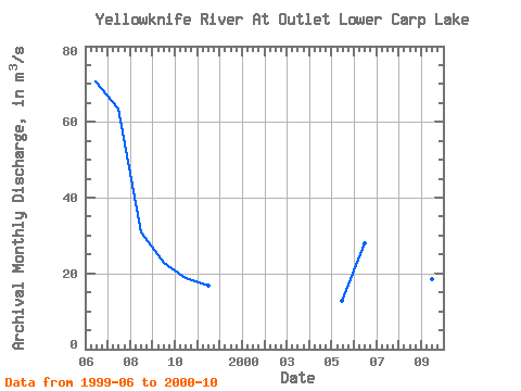
| Site Descriptor Information | Site Time Series Data |
| Link to all available data | |
|
|
| View: | Statistics | Time Series |
| Units: | mm |
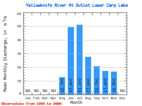
| Statistic | Jan | Feb | Mar | Apr | May | Jun | Jul | Aug | Sep | Oct | Nov | Dec | Annual |
|---|---|---|---|---|---|---|---|---|---|---|---|---|---|
| Mean | 12.70 | 49.40 | 51.10 | 27.60 | 20.70 | 17.40 | 16.90 | ||||||
| Standard Deviation | 30.26 | 17.39 | 4.38 | 3.11 | 2.12 | ||||||||
| Min | 12.70 | 28.00 | 38.80 | 24.50 | 18.50 | 15.90 | 16.90 | ||||||
| Max | 12.70 | 70.80 | 63.40 | 30.70 | 22.90 | 18.90 | 16.90 | ||||||
| Coefficient of Variation | 0.61 | 0.34 | 0.16 | 0.15 | 0.12 |
| Year | Jan | Feb | Mar | Apr | May | Jun | Jul | Aug | Sep | Oct | Nov | Dec | Annual | 1999 | 70.80 | 63.40 | 30.70 | 22.90 | 18.90 | 16.90 | 2000 | 12.70 | 28.00 | 38.80 | 24.50 | 18.50 | 15.90 |
|---|
 Return to R-Arctic Net Home Page