|
|
|||||||||||||||||
| Point ID: 9088 | Downloads | Plots | Site Data | Code: 9568 |
|
|
|||||||||||||||||
| Download | |
|---|---|
| Site Descriptor Information | Site Time Series Data |
| Link to all available data | |
|
|
| View: | Statistics | Time Series |
| Units: | mm |
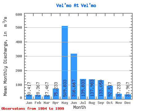
| Statistic | Jan | Feb | Mar | Apr | May | Jun | Jul | Aug | Sep | Oct | Nov | Dec | Annual |
|---|---|---|---|---|---|---|---|---|---|---|---|---|---|
| Mean | 30.42 | 28.37 | 27.47 | 75.23 | 509.83 | 316.67 | 139.83 | 137.98 | 133.05 | 92.52 | 37.23 | 33.97 | 130.21 |
| Standard Deviation | 5.50 | 4.99 | 3.76 | 116.53 | 212.03 | 102.80 | 41.33 | 49.56 | 60.39 | 39.84 | 8.25 | 8.76 | 21.01 |
| Min | 24.00 | 23.50 | 23.60 | 23.80 | 309.00 | 188.00 | 104.00 | 69.90 | 71.50 | 41.50 | 24.50 | 25.60 | 106.42 |
| Max | 39.60 | 35.20 | 33.20 | 313.00 | 910.00 | 465.00 | 200.00 | 203.00 | 219.00 | 157.00 | 48.20 | 50.40 | 163.28 |
| Coefficient of Variation | 0.18 | 0.18 | 0.14 | 1.55 | 0.42 | 0.33 | 0.30 | 0.36 | 0.45 | 0.43 | 0.22 | 0.26 | 0.16 |
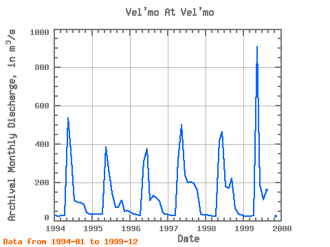
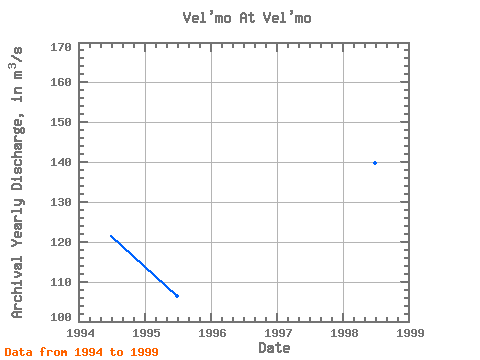
| Year | Jan | Feb | Mar | Apr | May | Jun | Jul | Aug | Sep | Oct | Nov | Dec | Annual | 1994 | 25.70 | 23.50 | 25.70 | 26.10 | 536.00 | 366.00 | 104.00 | 94.00 | 93.30 | 85.30 | 41.70 | 35.80 | 121.42 | 1995 | 32.30 | 33.60 | 33.20 | 33.90 | 387.00 | 266.00 | 145.00 | 69.90 | 71.50 | 106.00 | 48.20 | 50.40 | 106.42 | 1996 | 39.60 | 35.20 | 30.80 | 27.30 | 309.00 | 375.00 | 105.00 | 132.00 | 119.00 | 102.00 | 41.10 | 32.80 | 112.40 | 1997 | 30.60 | 27.60 | 26.90 | 313.00 | 499.00 | 240.00 | 200.00 | 203.00 | 197.00 | 157.00 | 34.90 | 30.30 | 163.28 | 1998 | 30.30 | 26.80 | 24.60 | 23.80 | 418.00 | 465.00 | 177.00 | 169.00 | 219.00 | 63.30 | 33.00 | 28.90 | 139.89 | 1999 | 24.00 | 23.50 | 23.60 | 27.30 | 910.00 | 188.00 | 108.00 | 160.00 | 98.50 | 41.50 | 24.50 | 25.60 | 137.88 |
|---|
 Return to R-Arctic Net Home Page