|
|
|||||||||||||||||
| Point ID: 9082 | Downloads | Plots | Site Data | Code: 49151 |
|
|
|||||||||||||||||
| Download | |
|---|---|
| Site Descriptor Information | Site Time Series Data |
| Link to all available data | |
|
|
| View: | Statistics | Time Series |
| Units: | mm |
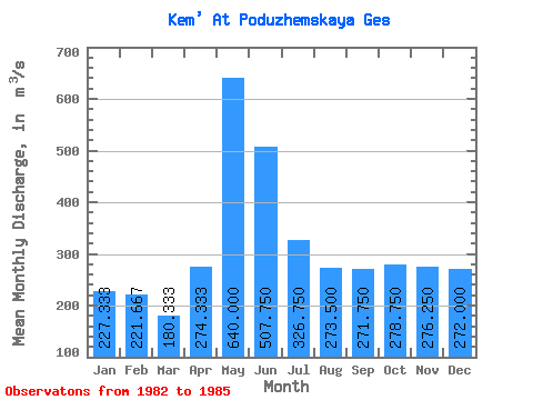
| Statistic | Jan | Feb | Mar | Apr | May | Jun | Jul | Aug | Sep | Oct | Nov | Dec | Annual |
|---|---|---|---|---|---|---|---|---|---|---|---|---|---|
| Mean | 227.33 | 221.67 | 180.33 | 274.33 | 640.00 | 507.75 | 326.75 | 273.50 | 271.75 | 278.75 | 276.25 | 272.00 | 300.83 |
| Standard Deviation | 9.45 | 20.26 | 26.50 | 107.48 | 153.25 | 206.14 | 83.54 | 30.96 | 47.42 | 41.77 | 77.76 | 65.21 | 52.63 |
| Min | 220.00 | 199.00 | 154.00 | 151.00 | 435.00 | 329.00 | 253.00 | 237.00 | 236.00 | 247.00 | 214.00 | 189.00 | 241.17 |
| Max | 238.00 | 238.00 | 207.00 | 348.00 | 806.00 | 731.00 | 404.00 | 303.00 | 338.00 | 338.00 | 379.00 | 327.00 | 340.67 |
| Coefficient of Variation | 0.04 | 0.09 | 0.15 | 0.39 | 0.24 | 0.41 | 0.26 | 0.11 | 0.17 | 0.15 | 0.28 | 0.24 | 0.17 |
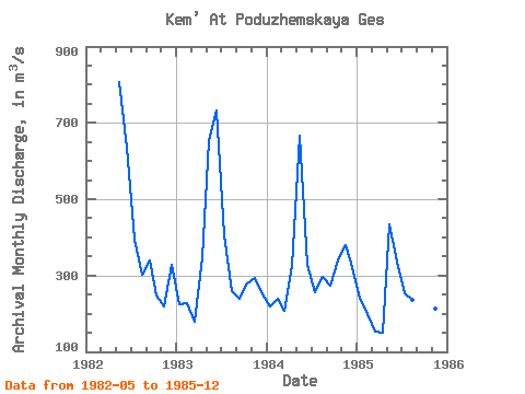
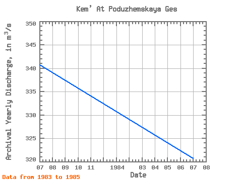
| Year | Jan | Feb | Mar | Apr | May | Jun | Jul | Aug | Sep | Oct | Nov | Dec | Annual | 1982 | 806.00 | 635.00 | 394.00 | 303.00 | 338.00 | 247.00 | 218.00 | 327.00 | 1983 | 224.00 | 228.00 | 180.00 | 348.00 | 652.00 | 731.00 | 404.00 | 259.00 | 239.00 | 278.00 | 294.00 | 251.00 | 340.67 | 1984 | 220.00 | 238.00 | 207.00 | 324.00 | 667.00 | 329.00 | 256.00 | 295.00 | 274.00 | 338.00 | 379.00 | 321.00 | 320.67 | 1985 | 238.00 | 199.00 | 154.00 | 151.00 | 435.00 | 336.00 | 253.00 | 237.00 | 236.00 | 252.00 | 214.00 | 189.00 | 241.17 |
|---|
 Return to R-Arctic Net Home Page