|
|
|||||||||||||||||
| Point ID: 9077 | Downloads | Plots | Site Data | Code: 49128 |
|
|
|||||||||||||||||
| Download | |
|---|---|
| Site Descriptor Information | Site Time Series Data |
| Link to all available data | |
| View: | Time Series | All |
| Units: | m3/s |
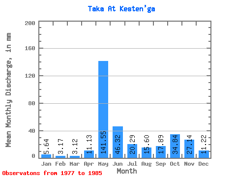
| Statistic | Jan | Feb | Mar | Apr | May | Jun | Jul | Aug | Sep | Oct | Nov | Dec | Annual |
|---|---|---|---|---|---|---|---|---|---|---|---|---|---|
| Mean | 5.64 | 3.21 | 3.12 | 11.13 | 141.52 | 46.32 | 20.29 | 15.60 | 17.89 | 34.83 | 27.14 | 11.23 | 335.50 |
| Standard Deviation | 2.86 | 1.40 | 1.34 | 17.10 | 44.32 | 28.60 | 10.82 | 12.89 | 8.40 | 13.73 | 13.83 | 4.70 | 87.95 |
| Min | 2.64 | 1.13 | 1.12 | 1.04 | 76.48 | 13.94 | 3.85 | 1.85 | 2.16 | 13.19 | 9.43 | 4.26 | 149.25 |
| Max | 11.36 | 6.10 | 5.07 | 55.57 | 206.94 | 104.86 | 36.11 | 42.60 | 28.86 | 56.20 | 55.18 | 19.88 | 423.19 |
| Coefficient of Variation | 0.51 | 0.43 | 0.43 | 1.54 | 0.31 | 0.62 | 0.53 | 0.83 | 0.47 | 0.39 | 0.51 | 0.42 | 0.26 |
 Return to R-Arctic Net Home Page