|
|
|||||||||||||||||
| Point ID: 9064 | Downloads | Plots | Site Data | Code: 49084 |
|
|
|||||||||||||||||
| Download | |
|---|---|
| Site Descriptor Information | Site Time Series Data |
| Link to all available data | |
|
|
| View: | Statistics | Time Series |
| Units: | mm |
| Statistic | Jan | Feb | Mar | Apr | May | Jun | Jul | Aug | Sep | Oct | Nov | Dec | Annual |
|---|---|---|---|---|---|---|---|---|---|---|---|---|---|
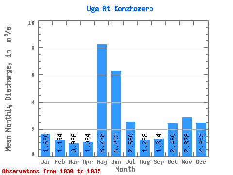
| Mean | 1.65 | 1.19 | 0.97 | 1.06 | 8.28 | 6.29 | 2.58 | 1.24 | 1.31 | 2.43 | 2.88 | 2.49 | 2.67 |
| Standard Deviation | 0.59 | 0.29 | 0.23 | 0.21 | 2.74 | 2.61 | 0.76 | 0.67 | 1.32 | 2.20 | 1.44 | 0.67 | 0.72 |
| Min | 0.86 | 0.77 | 0.69 | 0.72 | 5.40 | 4.41 | 1.70 | 0.67 | 0.43 | 0.48 | 1.38 | 1.70 | 2.10 |
| Max | 2.46 | 1.58 | 1.24 | 1.28 | 12.50 | 10.90 | 3.60 | 2.40 | 3.60 | 6.03 | 5.10 | 3.28 | 3.91 |
| Coefficient of Variation | 0.35 | 0.24 | 0.24 | 0.20 | 0.33 | 0.41 | 0.29 | 0.54 | 1.00 | 0.91 | 0.50 | 0.27 | 0.27 |
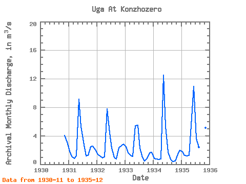
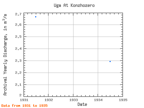
| Year | Jan | Feb | Mar | Apr | May | Jun | Jul | Aug | Sep | Oct | Nov | Dec | Annual | 1930 | 4.03 | 3.13 | 1931 | 1.80 | 1.14 | 0.83 | 1.17 | 9.14 | 5.30 | 3.09 | 1.17 | 1.28 | 2.46 | 2.56 | 2.04 | 2.67 | 1932 | 1.40 | 1.19 | 0.90 | 1.03 | 7.80 | 4.41 | 2.27 | 0.95 | 0.76 | 2.35 | 2.62 | 2.85 | 2.38 | 1933 | 2.46 | 1.58 | 1.24 | 1.12 | 5.40 | 5.50 | 2.24 | 1.00 | 0.50 | 0.83 | 1.58 | 1.70 | 2.10 | 1934 | 0.86 | 0.77 | 0.69 | 0.72 | 12.50 | 5.35 | 1.70 | 0.67 | 0.43 | 0.48 | 1.38 | 1.96 | 2.29 | 1935 | 1.73 | 1.29 | 1.17 | 1.28 | 6.55 | 10.90 | 3.60 | 2.40 | 3.60 | 6.03 | 5.10 | 3.28 | 3.91 |
|---|
 Return to R-Arctic Net Home Page