|
|
|||||||||||||||||
| Point ID: 9047 | Downloads | Plots | Site Data | Code: 49003 |
|
|
|||||||||||||||||
| Download | |
|---|---|
| Site Descriptor Information | Site Time Series Data |
| Link to all available data | |
|
|
| View: | Statistics | Time Series |
| Units: | mm |
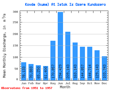
| Statistic | Jan | Feb | Mar | Apr | May | Jun | Jul | Aug | Sep | Oct | Nov | Dec | Annual |
|---|---|---|---|---|---|---|---|---|---|---|---|---|---|
| Mean | 78.13 | 70.88 | 65.25 | 61.40 | 170.86 | 294.43 | 209.14 | 163.14 | 144.86 | 144.71 | 129.14 | 103.74 | 138.58 |
| Standard Deviation | 15.89 | 8.11 | 10.13 | 12.56 | 48.09 | 75.01 | 48.20 | 26.11 | 31.19 | 41.86 | 39.65 | 27.54 | 16.72 |
| Min | 58.10 | 57.80 | 51.70 | 41.70 | 121.00 | 172.00 | 153.00 | 117.00 | 110.00 | 82.00 | 64.50 | 72.00 | 114.12 |
| Max | 99.20 | 78.70 | 77.20 | 76.30 | 261.00 | 419.00 | 283.00 | 201.00 | 187.00 | 199.00 | 168.00 | 136.00 | 164.68 |
| Coefficient of Variation | 0.20 | 0.11 | 0.15 | 0.20 | 0.28 | 0.26 | 0.23 | 0.16 | 0.21 | 0.29 | 0.31 | 0.27 | 0.12 |
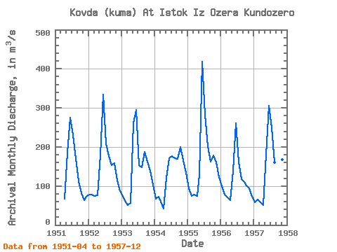
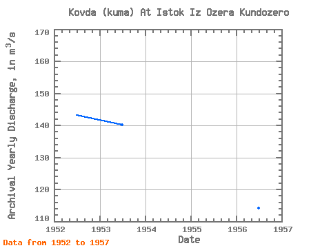
| Year | Jan | Feb | Mar | Apr | May | Jun | Jul | Aug | Sep | Oct | Nov | Dec | Annual | 1951 | 67.40 | 186.00 | 275.00 | 230.00 | 169.00 | 112.00 | 82.00 | 64.50 | 72.20 | 1952 | 77.50 | 77.10 | 74.50 | 76.30 | 180.00 | 335.00 | 209.00 | 176.00 | 154.00 | 158.00 | 114.00 | 87.00 | 143.20 | 1953 | 71.80 | 57.80 | 51.70 | 55.90 | 261.00 | 294.00 | 153.00 | 147.00 | 187.00 | 163.00 | 138.00 | 103.00 | 140.27 | 1954 | 67.70 | 71.80 | 60.00 | 41.70 | 121.00 | 172.00 | 176.00 | 171.00 | 170.00 | 199.00 | 165.00 | 133.00 | 129.02 | 1955 | 94.50 | 75.20 | 77.20 | 74.20 | 128.00 | 419.00 | 283.00 | 201.00 | 163.00 | 178.00 | 160.00 | 123.00 | 164.68 | 1956 | 99.20 | 78.70 | 70.00 | 63.10 | 139.00 | 261.00 | 163.00 | 117.00 | 110.00 | 102.00 | 94.50 | 72.00 | 114.12 | 1957 | 58.10 | 64.70 | 58.10 | 51.20 | 181.00 | 305.00 | 250.00 | 161.00 | 118.00 | 131.00 | 168.00 | 136.00 | 140.18 |
|---|
 Return to R-Arctic Net Home Page