|
|
|||||||||||||||||
| Point ID: 9030 | Downloads | Plots | Site Data | Code: 71238 |
|
|
|||||||||||||||||
| Download | |
|---|---|
| Site Descriptor Information | Site Time Series Data |
| Link to all available data | |
|
|
| View: | Statistics | Time Series |
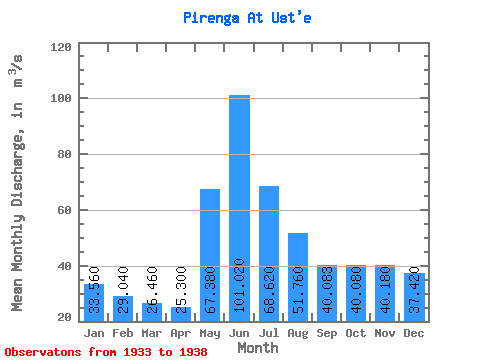
| Units: | mm |
| Statistic | Jan | Feb | Mar | Apr | May | Jun | Jul | Aug | Sep | Oct | Nov | Dec | Annual |
|---|---|---|---|---|---|---|---|---|---|---|---|---|---|
| Mean | 33.56 | 29.04 | 26.46 | 25.30 | 67.38 | 101.02 | 68.62 | 51.76 | 40.08 | 40.08 | 40.18 | 37.42 | 46.12 |
| Standard Deviation | 10.43 | 8.69 | 5.62 | 2.01 | 32.32 | 40.71 | 25.68 | 19.72 | 10.77 | 13.41 | 20.81 | 9.82 | 10.71 |
| Min | 25.40 | 21.60 | 21.20 | 23.00 | 35.10 | 63.20 | 38.90 | 25.10 | 25.30 | 21.20 | 6.00 | 22.30 | 30.61 |
| Max | 51.80 | 44.00 | 35.90 | 28.20 | 110.00 | 168.00 | 98.10 | 69.70 | 53.60 | 56.80 | 56.40 | 47.80 | 54.56 |
| Coefficient of Variation | 0.31 | 0.30 | 0.21 | 0.08 | 0.48 | 0.40 | 0.37 | 0.38 | 0.27 | 0.34 | 0.52 | 0.26 | 0.23 |
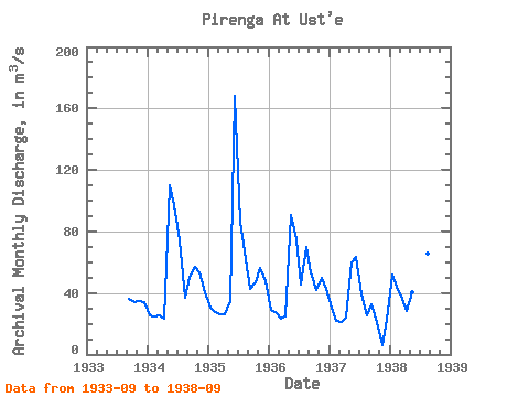
| Year | Jan | Feb | Mar | Apr | May | Jun | Jul | Aug | Sep | Oct | Nov | Dec | Annual | 1933 | 36.10 | 34.00 | 35.00 | 33.80 | 1934 | 25.40 | 24.90 | 25.70 | 23.00 | 110.00 | 97.30 | 74.40 | 36.60 | 50.30 | 56.80 | 53.50 | 40.70 | 51.55 | 1935 | 30.70 | 27.30 | 26.00 | 26.30 | 35.10 | 168.00 | 86.30 | 61.70 | 42.40 | 46.70 | 56.40 | 47.80 | 54.56 | 1936 | 29.10 | 27.40 | 23.50 | 24.80 | 91.00 | 74.60 | 45.40 | 69.70 | 53.60 | 41.70 | 50.00 | 42.50 | 47.77 | 1937 | 30.80 | 21.60 | 21.20 | 24.20 | 60.00 | 63.20 | 38.90 | 25.10 | 32.80 | 21.20 | 6.00 | 22.30 | 30.61 | 1938 | 51.80 | 44.00 | 35.90 | 28.20 | 40.80 | 102.00 | 98.10 | 65.70 | 25.30 |
|---|
 Return to R-Arctic Net Home Page