|
|
|||||||||||||||||
| Point ID: 9027 | Downloads | Plots | Site Data | Code: 71232 |
|
|
|||||||||||||||||
| Download | |
|---|---|
| Site Descriptor Information | Site Time Series Data |
| Link to all available data | |
|
|
| View: | Statistics | Time Series |
| Units: | mm |
| Statistic | Jan | Feb | Mar | Apr | May | Jun | Jul | Aug | Sep | Oct | Nov | Dec | Annual |
|---|---|---|---|---|---|---|---|---|---|---|---|---|---|
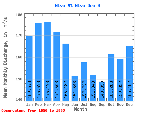
| Mean | 169.67 | 175.69 | 176.19 | 171.60 | 166.19 | 151.54 | 157.74 | 151.84 | 148.83 | 161.28 | 159.34 | 165.19 | 162.93 |
| Standard Deviation | 27.72 | 33.23 | 32.48 | 32.83 | 37.63 | 53.48 | 79.28 | 50.51 | 39.48 | 31.38 | 30.98 | 32.33 | 24.80 |
| Min | 55.20 | 40.80 | 42.80 | 83.10 | 80.60 | 76.40 | 76.40 | 87.80 | 12.40 | 73.50 | 81.10 | 66.60 | 87.67 |
| Max | 235.00 | 234.00 | 236.00 | 234.00 | 269.00 | 330.00 | 509.00 | 338.00 | 236.00 | 225.00 | 218.00 | 233.00 | 212.92 |
| Coefficient of Variation | 0.16 | 0.19 | 0.18 | 0.19 | 0.23 | 0.35 | 0.50 | 0.33 | 0.27 | 0.20 | 0.19 | 0.20 | 0.15 |
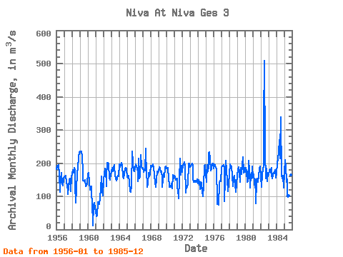
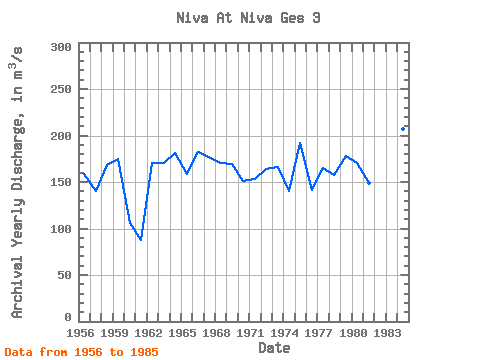
| Year | Jan | Feb | Mar | Apr | May | Jun | Jul | Aug | Sep | Oct | Nov | Dec | Annual | 1956 | 181.00 | 193.00 | 186.00 | 195.00 | 166.00 | 113.00 | 129.00 | 151.00 | 170.00 | 138.00 | 133.00 | 152.00 | 158.92 | 1957 | 161.00 | 159.00 | 163.00 | 144.00 | 132.00 | 114.00 | 106.00 | 131.00 | 149.00 | 154.00 | 115.00 | 157.00 | 140.42 | 1958 | 166.00 | 179.00 | 170.00 | 187.00 | 179.00 | 133.00 | 81.00 | 120.00 | 171.00 | 187.00 | 218.00 | 233.00 | 168.67 | 1959 | 235.00 | 234.00 | 236.00 | 221.00 | 173.00 | 147.00 | 148.00 | 146.00 | 149.00 | 130.00 | 133.00 | 139.00 | 174.25 | 1960 | 168.00 | 171.00 | 140.00 | 119.00 | 120.00 | 131.00 | 99.60 | 87.80 | 12.40 | 73.50 | 81.10 | 66.60 | 105.83 | 1961 | 55.20 | 40.80 | 42.80 | 83.10 | 80.60 | 76.40 | 76.40 | 95.70 | 121.00 | 160.00 | 117.00 | 103.00 | 87.67 | 1962 | 150.00 | 166.00 | 183.00 | 182.00 | 130.00 | 161.00 | 201.00 | 202.00 | 196.00 | 155.00 | 150.00 | 167.00 | 170.25 | 1963 | 174.00 | 185.00 | 176.00 | 186.00 | 194.00 | 188.00 | 164.00 | 151.00 | 147.00 | 153.00 | 162.00 | 161.00 | 170.08 | 1964 | 196.00 | 189.00 | 193.00 | 201.00 | 195.00 | 159.00 | 163.00 | 153.00 | 168.00 | 183.00 | 186.00 | 182.00 | 180.67 | 1965 | 159.00 | 156.00 | 163.00 | 144.00 | 114.00 | 127.00 | 113.00 | 132.00 | 236.00 | 201.00 | 177.00 | 175.00 | 158.08 | 1966 | 183.00 | 196.00 | 188.00 | 186.00 | 168.00 | 146.00 | 215.00 | 154.00 | 157.00 | 225.00 | 190.00 | 184.00 | 182.67 | 1967 | 187.00 | 173.00 | 181.00 | 177.00 | 244.00 | 222.00 | 181.00 | 129.00 | 137.00 | 170.00 | 161.00 | 167.00 | 177.42 | 1968 | 192.00 | 188.00 | 190.00 | 197.00 | 184.00 | 167.00 | 162.00 | 140.00 | 127.00 | 151.00 | 176.00 | 172.00 | 170.50 | 1969 | 177.00 | 189.00 | 184.00 | 173.00 | 176.00 | 155.00 | 128.00 | 151.00 | 169.00 | 158.00 | 187.00 | 191.00 | 169.83 | 1970 | 183.00 | 186.00 | 186.00 | 154.00 | 135.00 | 129.00 | 129.00 | 127.00 | 138.00 | 124.00 | 164.00 | 153.00 | 150.67 | 1971 | 162.00 | 158.00 | 149.00 | 151.00 | 154.00 | 124.00 | 122.00 | 94.60 | 149.00 | 213.00 | 164.00 | 193.00 | 152.80 | 1972 | 174.00 | 195.00 | 195.00 | 203.00 | 191.00 | 111.00 | 114.00 | 127.00 | 128.00 | 137.00 | 198.00 | 199.00 | 164.33 | 1973 | 188.00 | 191.00 | 195.00 | 199.00 | 191.00 | 154.00 | 142.00 | 144.00 | 148.00 | 143.00 | 143.00 | 151.00 | 165.75 | 1974 | 138.00 | 149.00 | 143.00 | 122.00 | 124.00 | 143.00 | 138.00 | 113.00 | 99.60 | 132.00 | 191.00 | 195.00 | 140.63 | 1975 | 165.00 | 142.00 | 195.00 | 176.00 | 189.00 | 230.00 | 234.00 | 215.00 | 177.00 | 181.00 | 199.00 | 199.00 | 191.83 | 1976 | 183.00 | 196.00 | 193.00 | 186.00 | 182.00 | 87.60 | 76.70 | 92.20 | 73.90 | 139.00 | 148.00 | 145.00 | 141.87 | 1977 | 186.00 | 192.00 | 191.00 | 195.00 | 189.00 | 84.50 | 151.00 | 207.00 | 177.00 | 150.00 | 114.00 | 139.00 | 164.62 | 1978 | 166.00 | 196.00 | 188.00 | 191.00 | 163.00 | 160.00 | 130.00 | 154.00 | 162.00 | 136.00 | 113.00 | 136.00 | 157.92 | 1979 | 165.00 | 180.00 | 188.00 | 172.00 | 144.00 | 168.00 | 186.00 | 167.00 | 192.00 | 218.00 | 171.00 | 187.00 | 178.17 | 1980 | 174.00 | 185.00 | 176.00 | 143.00 | 145.00 | 207.00 | 205.00 | 179.00 | 125.00 | 167.00 | 154.00 | 190.00 | 170.83 | 1981 | 155.00 | 166.00 | 140.00 | 125.00 | 151.00 | 78.20 | 143.00 | 154.00 | 144.00 | 163.00 | 182.00 | 190.00 | 149.27 | 1982 | 161.00 | 127.00 | 167.00 | 181.00 | 192.00 | 330.00 | 509.00 | 234.00 | 154.00 | 184.00 | 146.00 | 170.00 | 212.92 | 1983 | 164.00 | 179.00 | 182.00 | 177.00 | 160.00 | 186.00 | 153.00 | 164.00 | 171.00 | 171.00 | 180.00 | 156.00 | 170.25 | 1984 | 169.00 | 200.00 | 212.00 | 234.00 | 269.00 | 215.00 | 235.00 | 338.00 | 165.00 | 153.00 | 163.00 | 126.00 | 206.58 | 1985 | 173.00 | 210.00 | 190.00 | 144.00 | 151.00 | 99.60 | 97.40 | 102.00 | 152.00 | 189.00 | 164.00 | 177.00 | 154.08 |
|---|
 Return to R-Arctic Net Home Page