|
|
|||||||||||||||||
| Point ID: 9025 | Downloads | Plots | Site Data | Code: 71224 |
|
|
|||||||||||||||||
| Download | |
|---|---|
| Site Descriptor Information | Site Time Series Data |
| Link to all available data | |
|
|
| View: | Statistics | Time Series |
| Units: | mm |
| Statistic | Jan | Feb | Mar | Apr | May | Jun | Jul | Aug | Sep | Oct | Nov | Dec | Annual |
|---|---|---|---|---|---|---|---|---|---|---|---|---|---|
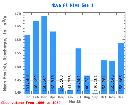
| Mean | 161.59 | 166.69 | 168.60 | 162.92 | 142.11 | 141.30 | 156.68 | 146.73 | 140.18 | 152.28 | 152.15 | 158.66 | 154.16 |
| Standard Deviation | 25.52 | 32.86 | 31.75 | 32.02 | 33.71 | 54.32 | 85.19 | 52.74 | 39.24 | 30.44 | 27.43 | 29.87 | 24.87 |
| Min | 55.30 | 40.00 | 41.70 | 81.90 | 68.50 | 58.60 | 69.50 | 84.20 | 15.50 | 69.30 | 80.80 | 71.20 | 82.51 |
| Max | 190.00 | 204.00 | 205.00 | 222.00 | 217.00 | 293.00 | 520.00 | 328.00 | 218.00 | 212.00 | 192.00 | 194.00 | 201.67 |
| Coefficient of Variation | 0.16 | 0.20 | 0.19 | 0.20 | 0.24 | 0.38 | 0.54 | 0.36 | 0.28 | 0.20 | 0.18 | 0.19 | 0.16 |
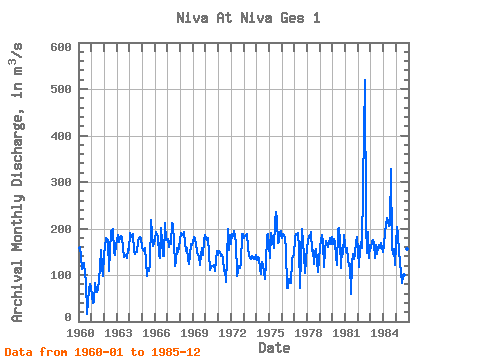
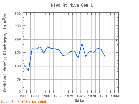
| Year | Jan | Feb | Mar | Apr | May | Jun | Jul | Aug | Sep | Oct | Nov | Dec | Annual | 1960 | 158.00 | 161.00 | 141.00 | 113.00 | 114.00 | 125.00 | 99.40 | 87.40 | 15.50 | 69.30 | 80.80 | 71.20 | 102.97 | 1961 | 55.30 | 40.00 | 41.70 | 81.90 | 68.50 | 62.40 | 69.50 | 87.70 | 118.00 | 154.00 | 114.00 | 97.10 | 82.51 | 1962 | 146.00 | 161.00 | 179.00 | 176.00 | 109.00 | 151.00 | 193.00 | 197.00 | 200.00 | 150.00 | 142.00 | 164.00 | 164.00 | 1963 | 173.00 | 185.00 | 172.00 | 179.00 | 184.00 | 182.00 | 159.00 | 138.00 | 144.00 | 136.00 | 155.00 | 153.00 | 163.33 | 1964 | 190.00 | 182.00 | 184.00 | 189.00 | 151.00 | 146.00 | 150.00 | 150.00 | 173.00 | 178.00 | 181.00 | 179.00 | 171.08 | 1965 | 157.00 | 152.00 | 157.00 | 129.00 | 98.30 | 116.00 | 108.00 | 121.00 | 218.00 | 188.00 | 163.00 | 167.00 | 147.86 | 1966 | 176.00 | 192.00 | 187.00 | 183.00 | 143.00 | 137.00 | 202.00 | 140.00 | 140.00 | 212.00 | 176.00 | 175.00 | 171.92 | 1967 | 177.00 | 161.00 | 173.00 | 166.00 | 211.00 | 207.00 | 172.00 | 120.00 | 129.00 | 159.00 | 150.00 | 161.00 | 165.50 | 1968 | 190.00 | 185.00 | 187.00 | 193.00 | 168.00 | 151.00 | 157.00 | 132.00 | 124.00 | 144.00 | 167.00 | 164.00 | 163.50 | 1969 | 171.00 | 181.00 | 178.00 | 166.00 | 149.00 | 139.00 | 122.00 | 144.00 | 158.00 | 144.00 | 176.00 | 186.00 | 159.50 | 1970 | 178.00 | 176.00 | 179.00 | 147.00 | 110.00 | 114.00 | 120.00 | 120.00 | 122.00 | 109.00 | 151.00 | 144.00 | 139.17 | 1971 | 152.00 | 149.00 | 140.00 | 142.00 | 135.00 | 109.00 | 110.00 | 84.20 | 135.00 | 200.00 | 153.00 | 186.00 | 141.27 | 1972 | 167.00 | 189.00 | 184.00 | 194.00 | 170.00 | 96.80 | 109.00 | 120.00 | 116.00 | 126.00 | 189.00 | 189.00 | 154.15 | 1973 | 179.00 | 183.00 | 187.00 | 188.00 | 159.00 | 140.00 | 137.00 | 134.00 | 140.00 | 134.00 | 135.00 | 143.00 | 154.92 | 1974 | 133.00 | 138.00 | 137.00 | 113.00 | 102.00 | 128.00 | 121.00 | 106.00 | 92.40 | 125.00 | 184.00 | 189.00 | 130.70 | 1975 | 162.00 | 137.00 | 191.00 | 171.00 | 157.00 | 217.00 | 235.00 | 219.00 | 168.00 | 172.00 | 192.00 | 194.00 | 184.58 | 1976 | 180.00 | 189.00 | 186.00 | 180.00 | 153.00 | 71.70 | 72.30 | 90.70 | 82.80 | 133.00 | 140.00 | 143.00 | 135.12 | 1977 | 180.00 | 188.00 | 186.00 | 191.00 | 158.00 | 72.60 | 143.00 | 199.00 | 169.00 | 142.00 | 105.00 | 132.00 | 155.47 | 1978 | 160.00 | 184.00 | 179.00 | 192.00 | 151.00 | 153.00 | 123.00 | 149.00 | 156.00 | 130.00 | 106.00 | 133.00 | 151.33 | 1979 | 161.00 | 176.00 | 187.00 | 170.00 | 118.00 | 153.00 | 174.00 | 161.00 | 169.00 | 180.00 | 166.00 | 181.00 | 166.33 | 1980 | 166.00 | 178.00 | 169.00 | 140.00 | 122.00 | 196.00 | 201.00 | 174.00 | 116.00 | 157.00 | 146.00 | 186.00 | 162.58 | 1981 | 150.00 | 159.00 | 135.00 | 120.00 | 124.00 | 58.60 | 125.00 | 145.00 | 134.00 | 146.00 | 170.00 | 181.00 | 137.30 | 1982 | 154.00 | 118.00 | 156.00 | 172.00 | 159.00 | 293.00 | 520.00 | 210.00 | 147.00 | 192.00 | 136.00 | 163.00 | 201.67 | 1983 | 158.00 | 173.00 | 176.00 | 169.00 | 137.00 | 165.00 | 146.00 | 157.00 | 164.00 | 157.00 | 168.00 | 150.00 | 160.00 | 1984 | 162.00 | 193.00 | 205.00 | 222.00 | 217.00 | 206.00 | 207.00 | 328.00 | 161.00 | 146.00 | 155.00 | 122.00 | 193.67 | 1985 | 166.00 | 204.00 | 187.00 | 149.00 | 127.00 | 83.60 | 98.50 | 101.00 | 153.00 | 176.00 | 155.00 | 172.00 | 147.68 |
|---|
 Return to R-Arctic Net Home Page