|
|
|||||||||||||||||
| Point ID: 9022 | Downloads | Plots | Site Data | Code: 71217 |
|
|
|||||||||||||||||
| Download | |
|---|---|
| Site Descriptor Information | Site Time Series Data |
| Link to all available data | |
|
|
| View: | Statistics | Time Series |
| Units: | mm |
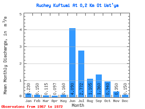
| Statistic | Jan | Feb | Mar | Apr | May | Jun | Jul | Aug | Sep | Oct | Nov | Dec | Annual |
|---|---|---|---|---|---|---|---|---|---|---|---|---|---|
| Mean | 0.23 | 0.15 | 0.12 | 0.10 | 0.16 | 4.09 | 2.77 | 1.10 | 1.36 | 0.94 | 0.35 | 0.15 | 1.07 |
| Standard Deviation | 0.01 | 0.01 | 0.08 | 1.36 | 1.13 | 0.46 | 0.56 | ||||||
| Min | 0.23 | 0.15 | 0.11 | 0.09 | 0.11 | 2.45 | 1.53 | 0.80 | 0.80 | 0.94 | 0.35 | 0.15 | 1.07 |
| Max | 0.23 | 0.15 | 0.12 | 0.10 | 0.25 | 5.53 | 4.00 | 1.79 | 2.09 | 0.94 | 0.35 | 0.15 | 1.07 |
| Coefficient of Variation | 0.06 | 0.05 | 0.49 | 0.33 | 0.41 | 0.42 | 0.41 |
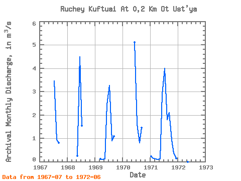
| Year | Jan | Feb | Mar | Apr | May | Jun | Jul | Aug | Sep | Oct | Nov | Dec | Annual | 1967 | 3.46 | 0.93 | 0.80 | 1968 | 0.25 | 4.48 | 1.53 | 1969 | 0.12 | 0.10 | 0.12 | 2.45 | 3.26 | 0.90 | 1.09 | 1970 | 5.11 | 1.61 | 0.80 | 1.46 | 1971 | 0.23 | 0.15 | 0.11 | 0.09 | 0.11 | 2.88 | 4.00 | 1.79 | 2.09 | 0.94 | 0.35 | 0.15 | 1.07 | 1972 | 5.53 |
|---|
 Return to R-Arctic Net Home Page