|
|
|||||||||||||||||
| Point ID: 9006 | Downloads | Plots | Site Data | Code: 71170 |
|
|
|||||||||||||||||
| Download | |
|---|---|
| Site Descriptor Information | Site Time Series Data |
| Link to all available data | |
| View: | Time Series | All |
| Units: | m3/s |
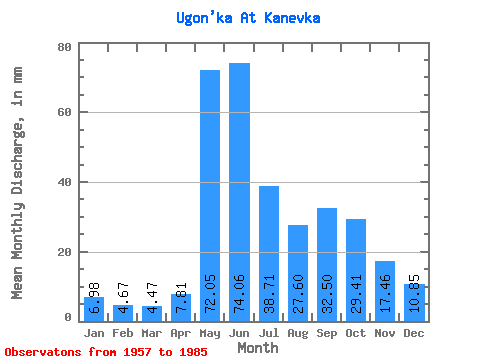
| Statistic | Jan | Feb | Mar | Apr | May | Jun | Jul | Aug | Sep | Oct | Nov | Dec | Annual |
|---|---|---|---|---|---|---|---|---|---|---|---|---|---|
| Mean | 6.98 | 4.71 | 4.47 | 7.81 | 72.04 | 74.06 | 38.70 | 27.60 | 32.50 | 29.41 | 17.46 | 10.85 | 328.22 |
| Standard Deviation | 1.96 | 1.64 | 1.85 | 7.38 | 43.09 | 29.22 | 16.88 | 10.54 | 9.19 | 11.60 | 7.10 | 3.17 | 74.31 |
| Min | 3.51 | 1.55 | 1.38 | 1.90 | 7.54 | 30.39 | 13.66 | 11.80 | 11.37 | 12.12 | 6.43 | 4.04 | 179.98 |
| Max | 10.47 | 8.71 | 9.14 | 32.09 | 191.29 | 135.77 | 83.95 | 53.67 | 49.42 | 57.39 | 30.14 | 17.54 | 464.63 |
| Coefficient of Variation | 0.28 | 0.35 | 0.41 | 0.94 | 0.60 | 0.40 | 0.44 | 0.38 | 0.28 | 0.39 | 0.41 | 0.29 | 0.23 |
 Return to R-Arctic Net Home Page