|
|
|||||||||||||||||
| Point ID: 8967 | Downloads | Plots | Site Data | Code: 71077 |
|
|
|||||||||||||||||
| Download | |
|---|---|
| Site Descriptor Information | Site Time Series Data |
| Link to all available data | |
| View: | Time Series | All |
| Units: | m3/s |
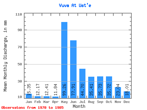
| Statistic | Jan | Feb | Mar | Apr | May | Jun | Jul | Aug | Sep | Oct | Nov | Dec | Annual |
|---|---|---|---|---|---|---|---|---|---|---|---|---|---|
| Mean | 15.35 | 12.27 | 12.41 | 11.84 | 99.24 | 77.91 | 44.69 | 35.41 | 35.73 | 35.71 | 23.04 | 18.01 | 389.44 |
| Standard Deviation | 1.91 | 1.43 | 1.33 | 2.04 | 27.89 | 26.72 | 19.37 | 13.19 | 13.16 | 12.99 | 5.05 | 3.05 | 72.79 |
| Min | 13.06 | 10.86 | 10.91 | 7.13 | 49.09 | 34.84 | 19.58 | 17.92 | 22.30 | 19.06 | 15.10 | 13.58 | 303.41 |
| Max | 19.17 | 15.78 | 15.24 | 15.76 | 161.99 | 123.00 | 79.09 | 70.09 | 67.83 | 54.81 | 30.62 | 22.39 | 524.02 |
| Coefficient of Variation | 0.12 | 0.12 | 0.11 | 0.17 | 0.28 | 0.34 | 0.43 | 0.37 | 0.37 | 0.36 | 0.22 | 0.17 | 0.19 |
 Return to R-Arctic Net Home Page