|
|
|||||||||||||||||
| Point ID: 8964 | Downloads | Plots | Site Data | Code: 71066 |
|
|
|||||||||||||||||
| Download | |
|---|---|
| Site Descriptor Information | Site Time Series Data |
| Link to all available data | |
|
|
| View: | Statistics | Time Series |
| Units: | mm |
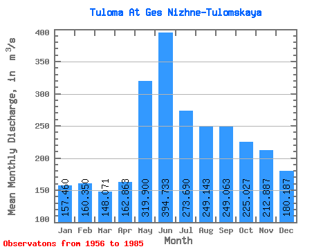
| Statistic | Jan | Feb | Mar | Apr | May | Jun | Jul | Aug | Sep | Oct | Nov | Dec | Annual |
|---|---|---|---|---|---|---|---|---|---|---|---|---|---|
| Mean | 157.46 | 160.35 | 148.07 | 162.86 | 319.90 | 394.73 | 273.69 | 249.14 | 249.06 | 225.03 | 212.89 | 180.19 | 227.78 |
| Standard Deviation | 64.15 | 74.39 | 76.19 | 73.85 | 153.83 | 217.78 | 145.06 | 108.28 | 83.71 | 83.77 | 81.34 | 67.82 | 50.36 |
| Min | 17.40 | 16.60 | 9.02 | 21.60 | 165.00 | 131.00 | 74.70 | 84.90 | 94.90 | 63.30 | 30.80 | 23.60 | 105.06 |
| Max | 259.00 | 278.00 | 278.00 | 273.00 | 797.00 | 933.00 | 694.00 | 520.00 | 417.00 | 410.00 | 358.00 | 285.00 | 296.42 |
| Coefficient of Variation | 0.41 | 0.46 | 0.52 | 0.45 | 0.48 | 0.55 | 0.53 | 0.43 | 0.34 | 0.37 | 0.38 | 0.38 | 0.22 |
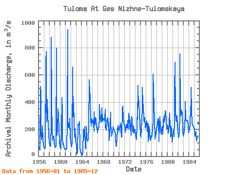
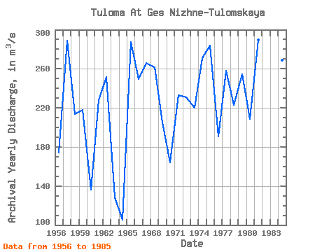
| Year | Jan | Feb | Mar | Apr | May | Jun | Jul | Aug | Sep | Oct | Nov | Dec | Annual | 1956 | 72.80 | 64.50 | 52.00 | 60.30 | 515.00 | 464.00 | 166.00 | 125.00 | 145.00 | 223.00 | 117.00 | 87.50 | 174.34 | 1957 | 67.10 | 63.80 | 55.80 | 65.20 | 699.00 | 773.00 | 387.00 | 254.00 | 417.00 | 286.00 | 244.00 | 158.00 | 289.16 | 1958 | 106.00 | 88.50 | 76.90 | 72.10 | 258.00 | 875.00 | 404.00 | 176.00 | 121.00 | 135.00 | 147.00 | 101.00 | 213.38 | 1959 | 76.80 | 70.30 | 67.10 | 78.50 | 797.00 | 220.00 | 155.00 | 201.00 | 350.00 | 299.00 | 194.00 | 109.00 | 218.14 | 1960 | 70.30 | 68.20 | 56.30 | 178.00 | 432.00 | 331.00 | 136.00 | 88.40 | 94.90 | 70.10 | 58.00 | 50.50 | 136.14 | 1961 | 48.70 | 49.70 | 50.50 | 59.50 | 248.00 | 933.00 | 286.00 | 214.00 | 221.00 | 207.00 | 276.00 | 139.00 | 227.70 | 1962 | 115.00 | 83.90 | 70.40 | 107.00 | 657.00 | 593.00 | 293.00 | 391.00 | 247.00 | 140.00 | 203.00 | 118.00 | 251.53 | 1963 | 94.70 | 86.00 | 21.10 | 30.70 | 239.00 | 222.00 | 234.00 | 232.00 | 257.00 | 67.40 | 30.80 | 23.60 | 128.19 | 1964 | 17.40 | 16.60 | 9.02 | 21.60 | 199.00 | 152.00 | 124.00 | 162.00 | 221.00 | 63.30 | 56.80 | 218.00 | 105.06 | 1965 | 125.00 | 116.00 | 113.00 | 119.00 | 220.00 | 563.00 | 512.00 | 512.00 | 404.00 | 269.00 | 225.00 | 273.00 | 287.58 | 1966 | 249.00 | 256.00 | 267.00 | 214.00 | 327.00 | 185.00 | 282.00 | 230.00 | 284.00 | 275.00 | 212.00 | 214.00 | 249.58 | 1967 | 173.00 | 205.00 | 207.00 | 216.00 | 286.00 | 381.00 | 295.00 | 292.00 | 248.00 | 268.00 | 358.00 | 261.00 | 265.83 | 1968 | 259.00 | 278.00 | 278.00 | 262.00 | 286.00 | 346.00 | 208.00 | 215.00 | 193.00 | 259.00 | 277.00 | 280.00 | 261.75 | 1969 | 218.00 | 248.00 | 116.00 | 170.00 | 232.00 | 325.00 | 220.00 | 208.00 | 149.00 | 173.00 | 179.00 | 218.00 | 204.67 | 1970 | 198.00 | 193.00 | 189.00 | 179.00 | 167.00 | 131.00 | 74.70 | 84.90 | 133.00 | 193.00 | 225.00 | 204.00 | 164.30 | 1971 | 185.00 | 204.00 | 218.00 | 243.00 | 212.00 | 204.00 | 142.00 | 145.00 | 355.00 | 367.00 | 276.00 | 242.00 | 232.75 | 1972 | 227.00 | 220.00 | 178.00 | 198.00 | 235.00 | 224.00 | 210.00 | 211.00 | 262.00 | 200.00 | 318.00 | 285.00 | 230.67 | 1973 | 207.00 | 268.00 | 213.00 | 156.00 | 276.00 | 293.00 | 272.00 | 186.00 | 179.00 | 221.00 | 171.00 | 199.00 | 220.08 | 1974 | 191.00 | 166.00 | 138.00 | 123.00 | 230.00 | 288.00 | 270.00 | 520.00 | 369.00 | 410.00 | 293.00 | 252.00 | 270.83 | 1975 | 157.00 | 140.00 | 199.00 | 268.00 | 358.00 | 506.00 | 384.00 | 379.00 | 268.00 | 255.00 | 285.00 | 208.00 | 283.92 | 1976 | 219.00 | 249.00 | 261.00 | 186.00 | 242.00 | 241.00 | 109.00 | 148.00 | 219.00 | 171.00 | 123.00 | 121.00 | 190.75 | 1977 | 151.00 | 143.00 | 154.00 | 204.00 | 265.00 | 603.00 | 487.00 | 369.00 | 277.00 | 128.00 | 155.00 | 163.00 | 258.25 | 1978 | 203.00 | 218.00 | 238.00 | 273.00 | 278.00 | 268.00 | 108.00 | 231.00 | 291.00 | 221.00 | 181.00 | 162.00 | 222.67 | 1979 | 206.00 | 222.00 | 162.00 | 254.00 | 291.00 | 270.00 | 253.00 | 279.00 | 334.00 | 322.00 | 263.00 | 201.00 | 254.75 | 1980 | 218.00 | 226.00 | 170.00 | 188.00 | 245.00 | 316.00 | 225.00 | 264.00 | 145.00 | 220.00 | 185.00 | 105.00 | 208.92 | 1981 | 151.00 | 171.00 | 192.00 | 144.00 | 271.00 | 485.00 | 694.00 | 322.00 | 263.00 | 255.00 | 304.00 | 219.00 | 289.25 | 1982 | 189.00 | 138.00 | 147.00 | 188.00 | 291.00 | 755.00 | 394.00 | 299.00 | 321.00 | 335.00 | 312.00 | 188.00 | 296.42 | 1983 | 150.00 | 167.00 | 185.00 | 229.00 | 310.00 | 402.00 | 266.00 | 260.00 | 263.00 | 267.00 | 252.00 | 231.00 | 248.50 | 1984 | 173.00 | 193.00 | 208.00 | 232.00 | 366.00 | 313.00 | 506.00 | 338.00 | 238.00 | 230.00 | 223.00 | 208.00 | 269.00 | 1985 | 206.00 | 198.00 | 150.00 | 167.00 | 165.00 | 180.00 | 114.00 | 138.00 | 203.00 | 221.00 | 243.00 | 167.00 | 179.33 |
|---|
 Return to R-Arctic Net Home Page