|
|
|||||||||||||||||
| Point ID: 8959 | Downloads | Plots | Site Data | Code: 71038 |
|
|
|||||||||||||||||
| Download | |
|---|---|
| Site Descriptor Information | Site Time Series Data |
| Link to all available data | |
| View: | Time Series | All |
| Units: | m3/s |
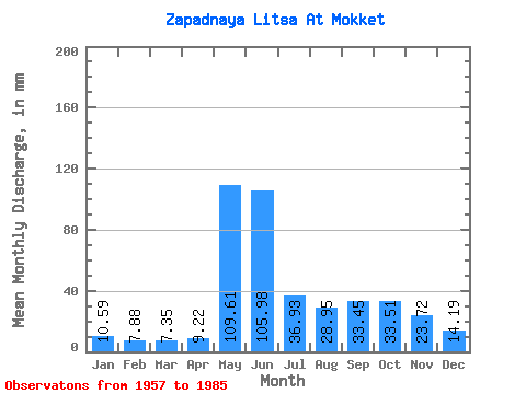
| Statistic | Jan | Feb | Mar | Apr | May | Jun | Jul | Aug | Sep | Oct | Nov | Dec | Annual |
|---|---|---|---|---|---|---|---|---|---|---|---|---|---|
| Mean | 10.59 | 7.95 | 7.35 | 9.22 | 109.60 | 105.98 | 36.92 | 28.94 | 33.45 | 33.50 | 23.72 | 14.19 | 422.24 |
| Standard Deviation | 2.68 | 1.69 | 1.87 | 6.74 | 57.23 | 50.24 | 21.04 | 17.68 | 14.68 | 11.61 | 11.10 | 3.43 | 95.56 |
| Min | 3.98 | 4.30 | 3.35 | 2.38 | 21.87 | 34.88 | 11.27 | 6.88 | 12.17 | 10.08 | 5.94 | 5.99 | 235.82 |
| Max | 15.40 | 10.88 | 11.23 | 32.80 | 226.51 | 206.64 | 94.10 | 77.74 | 67.32 | 57.28 | 69.48 | 21.35 | 589.56 |
| Coefficient of Variation | 0.25 | 0.21 | 0.25 | 0.73 | 0.52 | 0.47 | 0.57 | 0.61 | 0.44 | 0.35 | 0.47 | 0.24 | 0.23 |
 Return to R-Arctic Net Home Page