|
|
|||||||||||||||||
| Point ID: 8929 | Downloads | Plots | Site Data | Code: 70598 |
|
|
|||||||||||||||||
| Download | |
|---|---|
| Site Descriptor Information | Site Time Series Data |
| Link to all available data | |
|
|
| View: | Statistics | Time Series |
| Units: | mm |
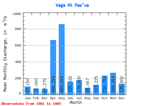
| Statistic | Jan | Feb | Mar | Apr | May | Jun | Jul | Aug | Sep | Oct | Nov | Dec | Annual |
|---|---|---|---|---|---|---|---|---|---|---|---|---|---|
| Mean | 97.15 | 72.00 | 69.28 | 666.25 | 860.00 | 155.33 | 178.00 | 85.07 | 119.22 | 230.75 | 268.25 | 135.80 | 268.57 |
| Standard Deviation | 45.26 | 20.75 | 12.65 | 595.82 | 450.03 | 43.11 | 65.83 | 12.82 | 44.88 | 87.32 | 104.03 | 58.18 | 2.03 |
| Min | 51.60 | 49.10 | 53.50 | 142.00 | 385.00 | 117.00 | 139.00 | 72.70 | 78.90 | 125.00 | 180.00 | 88.10 | 266.27 |
| Max | 139.00 | 90.70 | 84.00 | 1500.00 | 1280.00 | 202.00 | 254.00 | 98.30 | 176.00 | 327.00 | 417.00 | 216.00 | 270.09 |
| Coefficient of Variation | 0.47 | 0.29 | 0.18 | 0.89 | 0.52 | 0.28 | 0.37 | 0.15 | 0.38 | 0.38 | 0.39 | 0.43 | 0.01 |
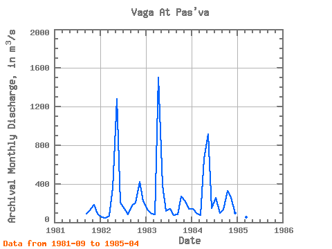
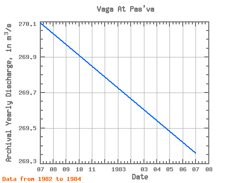
| Year | Jan | Feb | Mar | Apr | May | Jun | Jul | Aug | Sep | Oct | Nov | Dec | Annual | 1981 | 88.00 | 125.00 | 180.00 | 88.10 | 1982 | 51.60 | 49.10 | 67.20 | 358.00 | 1280.00 | 202.00 | 139.00 | 84.20 | 176.00 | 201.00 | 417.00 | 216.00 | 270.09 | 1983 | 133.00 | 90.70 | 84.00 | 1500.00 | 385.00 | 117.00 | 141.00 | 72.70 | 78.90 | 270.00 | 219.00 | 141.00 | 269.36 | 1984 | 139.00 | 88.40 | 72.40 | 665.00 | 915.00 | 147.00 | 254.00 | 98.30 | 134.00 | 327.00 | 257.00 | 98.10 | 266.27 | 1985 | 65.00 | 59.80 | 53.50 | 142.00 |
|---|
 Return to R-Arctic Net Home Page