|
|
|||||||||||||||||
| Point ID: 8927 | Downloads | Plots | Site Data | Code: 70594 |
|
|
|||||||||||||||||
| Download | |
|---|---|
| Site Descriptor Information | Site Time Series Data |
| Link to all available data | |
|
|
| View: | Statistics | Time Series |
| Units: | mm |
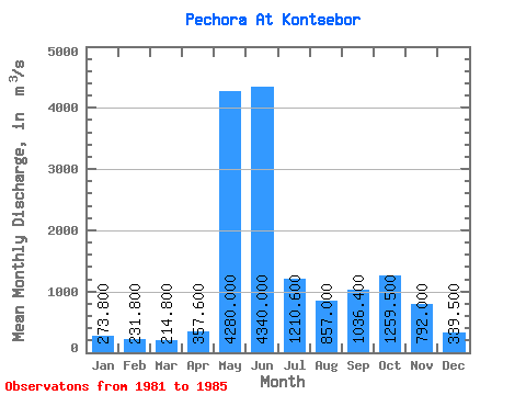
| Statistic | Jan | Feb | Mar | Apr | May | Jun | Jul | Aug | Sep | Oct | Nov | Dec | Annual |
|---|---|---|---|---|---|---|---|---|---|---|---|---|---|
| Mean | 273.80 | 231.80 | 214.80 | 357.60 | 4280.00 | 4340.00 | 1210.60 | 857.00 | 1036.40 | 1259.50 | 792.00 | 339.50 | 1358.83 |
| Standard Deviation | 52.22 | 26.96 | 17.88 | 275.47 | 1612.51 | 1673.89 | 400.24 | 342.47 | 424.85 | 651.25 | 5.66 | 53.03 | 368.64 |
| Min | 227.00 | 205.00 | 192.00 | 196.00 | 2460.00 | 1910.00 | 869.00 | 541.00 | 536.00 | 799.00 | 788.00 | 302.00 | 1098.17 |
| Max | 358.00 | 267.00 | 241.00 | 844.00 | 5710.00 | 5830.00 | 1860.00 | 1240.00 | 1560.00 | 1720.00 | 796.00 | 377.00 | 1619.50 |
| Coefficient of Variation | 0.19 | 0.12 | 0.08 | 0.77 | 0.38 | 0.39 | 0.33 | 0.40 | 0.41 | 0.52 | 0.01 | 0.16 | 0.27 |
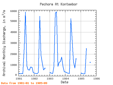
| Year | Jan | Feb | Mar | Apr | May | Jun | Jul | Aug | Sep | Oct | Nov | Dec | Annual | 1981 | 227.00 | 205.00 | 216.00 | 204.00 | 2590.00 | 5810.00 | 924.00 | 577.00 | 536.00 | 799.00 | 788.00 | 302.00 | 1098.17 | 1982 | 245.00 | 228.00 | 207.00 | 308.00 | 5430.00 | 1910.00 | 1100.00 | 541.00 | 696.00 | 1983 | 289.00 | 251.00 | 218.00 | 844.00 | 5710.00 | 5830.00 | 869.00 | 1210.00 | 1320.00 | 1720.00 | 796.00 | 377.00 | 1619.50 | 1984 | 358.00 | 267.00 | 241.00 | 236.00 | 5210.00 | 3450.00 | 1300.00 | 717.00 | 1560.00 | 1985 | 250.00 | 208.00 | 192.00 | 196.00 | 2460.00 | 4700.00 | 1860.00 | 1240.00 | 1070.00 |
|---|
 Return to R-Arctic Net Home Page