|
|
|||||||||||||||||
| Point ID: 8912 | Downloads | Plots | Site Data | Code: 70575 |
|
|
|||||||||||||||||
| Download | |
|---|---|
| Site Descriptor Information | Site Time Series Data |
| Link to all available data | |
| View: | Time Series | All |
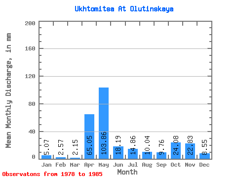
| Units: | m3/s |
| Statistic | Jan | Feb | Mar | Apr | May | Jun | Jul | Aug | Sep | Oct | Nov | Dec | Annual |
|---|---|---|---|---|---|---|---|---|---|---|---|---|---|
| Mean | 5.06 | 2.59 | 2.15 | 65.05 | 103.84 | 18.19 | 14.86 | 10.04 | 9.76 | 24.08 | 22.84 | 8.55 | 275.65 |
| Standard Deviation | 4.60 | 1.70 | 1.16 | 65.74 | 34.15 | 8.82 | 13.71 | 12.56 | 11.19 | 21.61 | 12.74 | 4.62 | 95.72 |
| Min | 1.16 | 1.01 | 1.05 | 4.55 | 40.84 | 7.31 | 4.53 | 0.55 | 1.52 | 4.01 | 8.38 | 2.32 | 171.79 |
| Max | 14.70 | 5.50 | 3.78 | 169.80 | 151.04 | 34.07 | 43.10 | 37.64 | 28.06 | 64.48 | 40.99 | 14.41 | 416.06 |
| Coefficient of Variation | 0.91 | 0.65 | 0.54 | 1.01 | 0.33 | 0.48 | 0.92 | 1.25 | 1.15 | 0.90 | 0.56 | 0.54 | 0.35 |
 Return to R-Arctic Net Home Page