|
|
|||||||||||||||||
| Point ID: 8890 | Downloads | Plots | Site Data | Code: 70547 |
|
|
|||||||||||||||||
| Download | |
|---|---|
| Site Descriptor Information | Site Time Series Data |
| Link to all available data | |
|
|
| View: | Statistics | Time Series |
| Units: | mm |
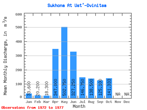
| Statistic | Jan | Feb | Mar | Apr | May | Jun | Jul | Aug | Sep | Oct | Nov | Dec | Annual |
|---|---|---|---|---|---|---|---|---|---|---|---|---|---|
| Mean | 33.60 | 20.20 | 18.30 | 347.00 | 502.75 | 327.25 | 146.75 | 138.50 | 125.10 | 141.33 | |||
| Standard Deviation | 191.93 | 188.17 | 29.38 | 31.39 | 19.78 | 39.50 | |||||||
| Min | 33.60 | 20.20 | 18.30 | 347.00 | 273.00 | 138.00 | 111.00 | 101.00 | 99.40 | 111.00 | |||
| Max | 33.60 | 20.20 | 18.30 | 347.00 | 691.00 | 538.00 | 179.00 | 172.00 | 143.00 | 186.00 | |||
| Coefficient of Variation | 0.38 | 0.57 | 0.20 | 0.23 | 0.16 | 0.28 |
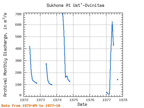
| Year | Jan | Feb | Mar | Apr | May | Jun | Jul | Aug | Sep | Oct | Nov | Dec | Annual | 1972 | 420.00 | 203.00 | 137.00 | 126.00 | 120.00 | 111.00 | 1973 | 273.00 | 138.00 | 111.00 | 101.00 | 99.40 | 1974 | 691.00 | 538.00 | 160.00 | 172.00 | 138.00 | 127.00 | 1977 | 33.60 | 20.20 | 18.30 | 347.00 | 627.00 | 430.00 | 179.00 | 155.00 | 143.00 | 186.00 |
|---|
 Return to R-Arctic Net Home Page