|
|
|||||||||||||||||
| Point ID: 889 | Downloads | Plots | Site Data | Code: 07FB010 |
|
|
|||||||||||||||||
| Download | |
|---|---|
| Site Descriptor Information | Site Time Series Data |
| Link to all available data | |
|
|
| View: | Statistics | Time Series |
| Units: | mm |
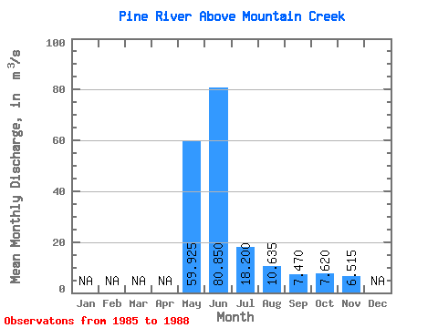
| Statistic | Jan | Feb | Mar | Apr | May | Jun | Jul | Aug | Sep | Oct | Nov | Dec | Annual |
|---|---|---|---|---|---|---|---|---|---|---|---|---|---|
| Mean | 59.92 | 80.85 | 18.20 | 10.63 | 7.47 | 7.62 | 6.51 | ||||||
| Standard Deviation | 16.13 | 22.72 | 6.88 | 8.07 | 3.07 | 1.86 | 0.73 | ||||||
| Min | 45.00 | 53.20 | 11.90 | 4.98 | 5.27 | 5.49 | 6.00 | ||||||
| Max | 77.70 | 104.00 | 24.40 | 22.60 | 12.00 | 8.94 | 7.03 | ||||||
| Coefficient of Variation | 0.27 | 0.28 | 0.38 | 0.76 | 0.41 | 0.24 | 0.11 |
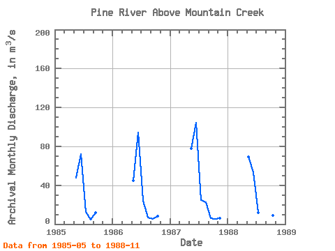
| Year | Jan | Feb | Mar | Apr | May | Jun | Jul | Aug | Sep | Oct | Nov | Dec | Annual | 1985 | 47.60 | 72.20 | 12.60 | 4.98 | 12.00 | 1986 | 45.00 | 94.00 | 23.90 | 7.00 | 5.27 | 8.43 | 1987 | 77.70 | 104.00 | 24.40 | 22.60 | 6.00 | 5.49 | 6.00 | 1988 | 69.40 | 53.20 | 11.90 | 7.96 | 6.61 | 8.94 | 7.03 |
|---|
 Return to R-Arctic Net Home Page