|
|
|||||||||||||||||
| Point ID: 8863 | Downloads | Plots | Site Data | Code: 70357 |
|
|
|||||||||||||||||
| Download | |
|---|---|
| Site Descriptor Information | Site Time Series Data |
| Link to all available data | |
|
|
| View: | Statistics | Time Series |
| Units: | mm |
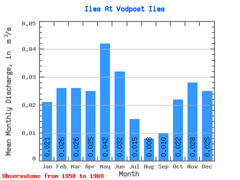
| Statistic | Jan | Feb | Mar | Apr | May | Jun | Jul | Aug | Sep | Oct | Nov | Dec | Annual |
|---|---|---|---|---|---|---|---|---|---|---|---|---|---|
| Mean | 0.02 | 0.03 | 0.03 | 0.03 | 0.04 | 0.03 | 0.01 | 0.01 | 0.01 | 0.02 | 0.03 | 0.03 | 0.02 |
| Standard Deviation | 0.01 | 0.01 | 0.01 | 0.01 | 0.01 | 0.02 | 0.01 | 0.01 | 0.01 | 0.01 | 0.02 | 0.02 | 0.01 |
| Min | 0.00 | 0.00 | 0.00 | 0.00 | 0.02 | 0.01 | 0.00 | 0.00 | 0.00 | 0.01 | 0.01 | 0.00 | 0.01 |
| Max | 0.05 | 0.05 | 0.05 | 0.05 | 0.07 | 0.08 | 0.04 | 0.02 | 0.03 | 0.04 | 0.06 | 0.05 | 0.04 |
| Coefficient of Variation | 0.65 | 0.50 | 0.55 | 0.53 | 0.35 | 0.74 | 0.69 | 0.75 | 0.73 | 0.59 | 0.55 | 0.67 | 0.33 |
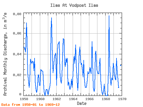
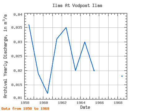
| Year | Jan | Feb | Mar | Apr | May | Jun | Jul | Aug | Sep | Oct | Nov | Dec | Annual | 1958 | 0.05 | 0.05 | 0.04 | 0.04 | 0.07 | 0.05 | 0.02 | 0.01 | 0.01 | 0.01 | 0.04 | 0.03 | 0.04 | 1959 | 0.03 | 0.03 | 0.03 | 0.02 | 0.04 | 0.01 | 0.01 | 0.00 | 0.01 | 0.02 | 0.02 | 0.01 | 0.02 | 1960 | 0.01 | 0.03 | 0.02 | 0.02 | 0.02 | 0.01 | 0.00 | 0.00 | 0.00 | 0.01 | 0.01 | 0.00 | 0.01 | 1961 | 0.00 | 0.01 | 0.01 | 0.01 | 0.06 | 0.07 | 0.04 | 0.02 | 0.03 | 0.04 | 0.04 | 0.04 | 0.03 | 1962 | 0.01 | 0.04 | 0.05 | 0.05 | 0.05 | 0.02 | 0.01 | 0.01 | 0.02 | 0.04 | 0.06 | 0.05 | 0.04 | 1963 | 0.03 | 0.03 | 0.04 | 0.03 | 0.04 | 0.01 | 0.01 | 0.01 | 0.01 | 0.01 | 0.02 | 0.01 | 0.02 | 1964 | 0.02 | 0.03 | 0.04 | 0.03 | 0.05 | 0.03 | 0.02 | 0.01 | 0.01 | 0.04 | 0.05 | 0.04 | 0.03 | 1965 | 0.03 | 0.03 | 0.02 | 0.02 | 0.03 | 0.02 | 0.01 | 0.01 | 0.01 | 0.01 | 0.02 | 0.02 | 0.02 | 1966 | 0.02 | 0.03 | 0.02 | 0.02 | 0.05 | 0.03 | 0.01 | 0.00 | 0.01 | 0.04 | 0.04 | 0.03 | 0.03 | 1967 | 0.02 | 0.02 | 0.02 | 0.03 | 0.04 | 0.01 | 0.01 | 0.00 | 0.00 | 0.01 | 0.01 | 0.00 | 0.01 | 1968 | 0.00 | 0.00 | 0.00 | 0.00 | 0.02 | 0.08 | 0.03 | 0.01 | 0.01 | 0.02 | 0.01 | 0.03 | 0.02 | 1969 | 0.03 | 0.02 | 0.02 | 0.01 | 0.04 | 0.03 | 0.01 | 0.01 | 0.01 | 0.03 | 0.03 | 0.04 | 0.02 |
|---|
 Return to R-Arctic Net Home Page