|
|
|||||||||||||||||
| Point ID: 8836 | Downloads | Plots | Site Data | Code: 70048 |
|
|
|||||||||||||||||
| Download | |
|---|---|
| Site Descriptor Information | Site Time Series Data |
| Link to all available data | |
|
|
| View: | Statistics | Time Series |
| Units: | mm |
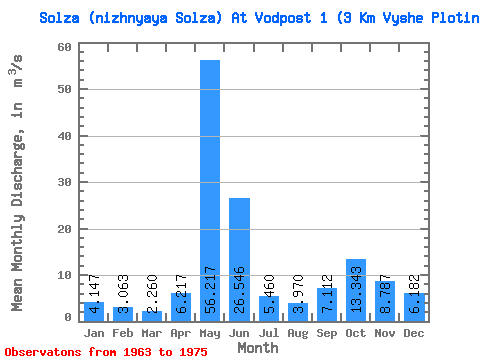
| Statistic | Jan | Feb | Mar | Apr | May | Jun | Jul | Aug | Sep | Oct | Nov | Dec | Annual |
|---|---|---|---|---|---|---|---|---|---|---|---|---|---|
| Mean | 4.15 | 3.06 | 2.26 | 6.22 | 56.22 | 26.55 | 5.46 | 3.97 | 7.11 | 13.34 | 8.79 | 6.18 | 11.62 |
| Standard Deviation | 1.61 | 1.11 | 0.48 | 4.01 | 8.11 | 17.31 | 4.11 | 2.05 | 5.40 | 10.07 | 4.33 | 3.64 | 2.55 |
| Min | 2.15 | 1.83 | 1.42 | 1.71 | 45.10 | 8.83 | 1.84 | 1.30 | 1.45 | 2.74 | 3.40 | 2.75 | 8.85 |
| Max | 6.21 | 4.88 | 2.92 | 11.30 | 66.10 | 50.60 | 12.50 | 6.48 | 17.20 | 26.00 | 14.10 | 13.00 | 15.31 |
| Coefficient of Variation | 0.39 | 0.36 | 0.21 | 0.65 | 0.14 | 0.65 | 0.75 | 0.52 | 0.76 | 0.76 | 0.49 | 0.59 | 0.22 |
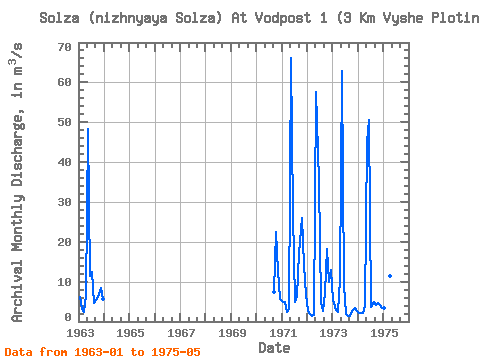
| Year | Jan | Feb | Mar | Apr | May | Jun | Jul | Aug | Sep | Oct | Nov | Dec | Annual | 1963 | 6.21 | 3.23 | 2.35 | 6.69 | 48.40 | 11.30 | 12.50 | 4.61 | 5.31 | 6.14 | 8.36 | 5.66 | 10.06 | 1970 | 7.46 | 22.40 | 12.60 | 5.61 | 1971 | 5.00 | 4.88 | 2.38 | 3.22 | 66.10 | 26.90 | 4.87 | 6.48 | 17.20 | 26.00 | 14.10 | 6.60 | 15.31 | 1972 | 2.67 | 1.83 | 1.42 | 1.71 | 57.60 | 35.10 | 4.55 | 2.53 | 7.10 | 18.20 | 10.00 | 13.00 | 12.98 | 1973 | 5.35 | 2.89 | 2.29 | 10.60 | 62.80 | 8.83 | 1.84 | 1.30 | 1.45 | 2.74 | 3.40 | 2.75 | 8.85 | 1974 | 2.15 | 2.04 | 2.20 | 3.78 | 45.10 | 50.60 | 3.54 | 4.93 | 4.15 | 4.58 | 4.26 | 3.47 | 10.90 | 1975 | 3.50 | 3.51 | 2.92 | 11.30 | 57.30 |
|---|
 Return to R-Arctic Net Home Page