|
|
|||||||||||||||||
| Point ID: 8816 | Downloads | Plots | Site Data | Code: 12380 |
|
|
|||||||||||||||||
| Download | |
|---|---|
| Site Descriptor Information | Site Time Series Data |
| Link to all available data | |
|
|
| View: | Statistics | Time Series |
| Units: | mm |
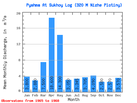
| Statistic | Jan | Feb | Mar | Apr | May | Jun | Jul | Aug | Sep | Oct | Nov | Dec | Annual |
|---|---|---|---|---|---|---|---|---|---|---|---|---|---|
| Mean | 3.80 | 2.88 | 7.50 | 18.60 | 14.30 | 3.05 | 3.34 | 3.71 | 4.09 | 2.58 | 2.57 | 3.57 | |
| Standard Deviation | 16.26 | 0.35 | 1.93 | 2.41 | |||||||||
| Min | 3.80 | 2.88 | 7.50 | 18.60 | 2.80 | 2.80 | 1.98 | 2.00 | 4.09 | 2.58 | 2.57 | 3.57 | |
| Max | 3.80 | 2.88 | 7.50 | 18.60 | 25.80 | 3.30 | 4.71 | 5.41 | 4.09 | 2.58 | 2.57 | 3.57 | |
| Coefficient of Variation | 1.14 | 0.12 | 0.58 | 0.65 |
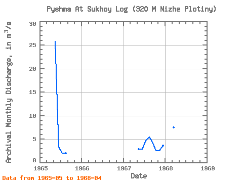
| Year | Jan | Feb | Mar | Apr | May | Jun | Jul | Aug | Sep | Oct | Nov | Dec | Annual | 1965 | 25.80 | 3.30 | 1.98 | 2.00 | 1967 | 2.80 | 2.80 | 4.71 | 5.41 | 4.09 | 2.58 | 2.57 | 3.57 | 1968 | 3.80 | 2.88 | 7.50 | 18.60 |
|---|
 Return to R-Arctic Net Home Page