|
|
|||||||||||||||||
| Point ID: 881 | Downloads | Plots | Site Data | Code: 07FB002 |
|
|
|||||||||||||||||
| Download | |
|---|---|
| Site Descriptor Information | Site Time Series Data |
| Link to all available data | |
|
|
| View: | Statistics | Time Series |
| Units: | mm |
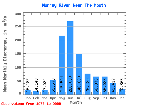
| Statistic | Jan | Feb | Mar | Apr | May | Jun | Jul | Aug | Sep | Oct | Nov | Dec | Annual |
|---|---|---|---|---|---|---|---|---|---|---|---|---|---|
| Mean | 16.18 | 14.14 | 17.03 | 53.68 | 215.50 | 268.03 | 148.63 | 76.43 | 66.38 | 66.03 | 41.42 | 20.86 | 83.45 |
| Standard Deviation | 4.38 | 4.18 | 7.46 | 27.89 | 61.96 | 87.26 | 62.33 | 35.71 | 40.45 | 37.84 | 18.71 | 6.19 | 16.24 |
| Min | 8.53 | 8.30 | 7.72 | 17.40 | 98.60 | 89.70 | 56.70 | 32.40 | 24.20 | 30.00 | 12.20 | 9.47 | 51.69 |
| Max | 27.20 | 28.20 | 40.40 | 115.00 | 358.00 | 466.00 | 311.00 | 183.00 | 164.00 | 187.00 | 96.70 | 36.80 | 118.30 |
| Coefficient of Variation | 0.27 | 0.30 | 0.44 | 0.52 | 0.29 | 0.33 | 0.42 | 0.47 | 0.61 | 0.57 | 0.45 | 0.30 | 0.20 |
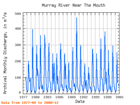
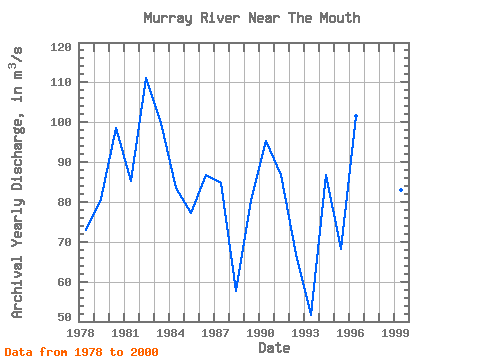
| Year | Jan | Feb | Mar | Apr | May | Jun | Jul | Aug | Sep | Oct | Nov | Dec | Annual | 1977 | 91.70 | 103.00 | 45.70 | 20.10 | 1978 | 15.10 | 12.20 | 11.10 | 27.10 | 156.00 | 201.00 | 110.00 | 80.30 | 72.10 | 73.60 | 96.70 | 20.60 | 72.98 | 1979 | 13.90 | 10.30 | 12.90 | 25.10 | 172.00 | 395.00 | 183.00 | 61.70 | 38.70 | 35.10 | 12.20 | 9.47 | 80.78 | 1980 | 8.53 | 8.30 | 7.72 | 35.30 | 193.00 | 296.00 | 180.00 | 110.00 | 151.00 | 106.00 | 52.80 | 34.30 | 98.58 | 1981 | 27.20 | 28.20 | 31.40 | 47.80 | 358.00 | 241.00 | 106.00 | 47.90 | 28.80 | 30.00 | 54.70 | 23.00 | 85.33 | 1982 | 13.60 | 11.50 | 9.77 | 17.40 | 201.00 | 361.00 | 290.00 | 161.00 | 137.00 | 66.30 | 39.60 | 26.30 | 111.21 | 1983 | 17.40 | 13.40 | 13.40 | 64.60 | 211.00 | 262.00 | 311.00 | 84.60 | 73.60 | 67.90 | 59.90 | 17.70 | 99.71 | 1984 | 14.80 | 16.30 | 17.70 | 32.60 | 118.00 | 246.00 | 123.00 | 60.70 | 94.40 | 187.00 | 62.50 | 28.20 | 83.43 | 1985 | 19.10 | 12.10 | 13.70 | 35.90 | 190.00 | 247.00 | 108.00 | 61.10 | 109.00 | 75.30 | 34.90 | 19.30 | 77.12 | 1986 | 17.50 | 15.70 | 26.70 | 51.00 | 229.00 | 308.00 | 182.00 | 60.20 | 40.70 | 56.10 | 31.00 | 22.30 | 86.68 | 1987 | 24.30 | 21.10 | 16.20 | 60.30 | 230.00 | 247.00 | 92.20 | 183.00 | 41.90 | 32.80 | 50.40 | 18.90 | 84.84 | 1988 | 13.30 | 13.20 | 16.00 | 50.40 | 171.00 | 192.00 | 91.60 | 50.30 | 24.20 | 35.30 | 19.90 | 14.90 | 57.67 | 1989 | 13.30 | 11.70 | 10.30 | 30.80 | 238.00 | 286.00 | 110.00 | 80.10 | 43.70 | 43.40 | 62.40 | 36.80 | 80.54 | 1990 | 23.40 | 16.20 | 21.10 | 60.90 | 269.00 | 466.00 | 135.00 | 49.90 | 32.10 | 30.30 | 22.40 | 17.20 | 95.29 | 1991 | 13.70 | 13.70 | 14.70 | 95.90 | 278.00 | 299.00 | 121.00 | 56.40 | 46.00 | 52.60 | 28.30 | 21.50 | 86.73 | 1992 | 18.40 | 15.20 | 40.40 | 102.00 | 157.00 | 185.00 | 56.70 | 32.40 | 65.90 | 84.20 | 31.80 | 14.10 | 66.92 | 1993 | 9.65 | 8.81 | 10.10 | 29.00 | 163.00 | 89.70 | 115.00 | 63.80 | 34.00 | 35.70 | 40.40 | 21.10 | 51.69 | 1994 | 13.00 | 10.80 | 20.90 | 115.00 | 270.00 | 275.00 | 146.00 | 54.20 | 44.70 | 45.00 | 27.50 | 18.40 | 86.71 | 1995 | 15.80 | 15.50 | 18.80 | 45.90 | 246.00 | 184.00 | 101.00 | 80.10 | 35.50 | 33.80 | 21.70 | 19.10 | 68.10 | 1996 | 14.70 | 13.60 | 14.70 | 82.50 | 206.00 | 338.00 | 209.00 | 102.00 | 92.80 | 89.80 | 35.60 | 19.40 | 101.51 | 1997 | 16.10 | 16.10 | 19.30 | 95.10 | 323.00 | 381.00 | 213.00 | 85.40 | 60.80 | 134.00 | 54.60 | 21.20 | 118.30 | 1998 | 17.70 | 16.10 | 16.00 | 36.00 | 268.00 | 116.00 | 112.00 | 39.20 | 26.20 | 48.90 | 28.50 | 17.80 | 61.87 | 1999 | 13.40 | 12.90 | 14.10 | 68.10 | 211.00 | 295.00 | 158.00 | 81.00 | 44.20 | 43.40 | 27.80 | 26.30 | 82.93 | 2000 | 18.30 | 12.30 | 14.80 | 25.90 | 98.60 | 254.00 | 165.00 | 72.60 | 164.00 | 75.30 | 52.70 | 12.80 | 80.53 |
|---|
 Return to R-Arctic Net Home Page