|
|
|||||||||||||||||
| Point ID: 8798 | Downloads | Plots | Site Data | Code: 12262 |
|
|
|||||||||||||||||
| Download | |
|---|---|
| Site Descriptor Information | Site Time Series Data |
| Link to all available data | |
|
|
| View: | Statistics | Time Series |
| Units: | mm |
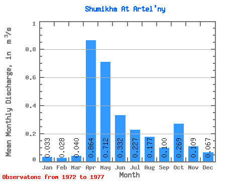
| Statistic | Jan | Feb | Mar | Apr | May | Jun | Jul | Aug | Sep | Oct | Nov | Dec | Annual |
|---|---|---|---|---|---|---|---|---|---|---|---|---|---|
| Mean | 0.03 | 0.03 | 0.04 | 0.86 | 0.71 | 0.33 | 0.23 | 0.18 | 0.10 | 0.27 | 0.11 | 0.07 | 0.27 |
| Standard Deviation | 0.03 | 0.03 | 0.03 | 0.61 | 0.42 | 0.32 | 0.24 | 0.07 | 0.03 | 0.25 | 0.07 | 0.04 | 0.09 |
| Min | 0.00 | 0.00 | 0.00 | 0.53 | 0.32 | 0.06 | 0.05 | 0.05 | 0.06 | 0.05 | 0.03 | 0.02 | 0.18 |
| Max | 0.07 | 0.06 | 0.07 | 1.96 | 1.42 | 0.88 | 0.60 | 0.23 | 0.13 | 0.67 | 0.22 | 0.11 | 0.35 |
| Coefficient of Variation | 0.84 | 0.89 | 0.71 | 0.71 | 0.59 | 0.95 | 1.04 | 0.41 | 0.29 | 0.92 | 0.65 | 0.54 | 0.35 |
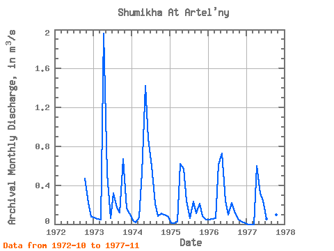
| Year | Jan | Feb | Mar | Apr | May | Jun | Jul | Aug | Sep | Oct | Nov | Dec | Annual | 1972 | 0.47 | 0.22 | 0.07 | 1973 | 0.07 | 0.06 | 0.04 | 1.96 | 0.52 | 0.06 | 0.32 | 0.17 | 0.12 | 0.67 | 0.16 | 0.11 | 0.35 | 1974 | 0.04 | 0.02 | 0.07 | 0.53 | 1.42 | 0.88 | 0.60 | 0.21 | 0.08 | 0.11 | 0.10 | 0.09 | 0.35 | 1975 | 0.01 | 0.01 | 0.02 | 0.62 | 0.57 | 0.24 | 0.06 | 0.23 | 0.11 | 0.21 | 0.09 | 0.05 | 0.18 | 1976 | 0.05 | 0.06 | 0.06 | 0.61 | 0.73 | 0.24 | 0.10 | 0.22 | 0.13 | 0.05 | 0.03 | 0.02 | 0.19 | 1977 | 0.00 | 0.00 | 0.00 | 0.60 | 0.32 | 0.24 | 0.05 | 0.05 | 0.06 | 0.10 | 0.06 |
|---|
 Return to R-Arctic Net Home Page