|
|
|||||||||||||||||
| Point ID: 8793 | Downloads | Plots | Site Data | Code: 12229 |
|
|
|||||||||||||||||
| Download | |
|---|---|
| Site Descriptor Information | Site Time Series Data |
| Link to all available data | |
|
|
| View: | Statistics | Time Series |
| Units: | mm |
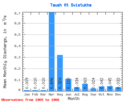
| Statistic | Jan | Feb | Mar | Apr | May | Jun | Jul | Aug | Sep | Oct | Nov | Dec | Annual |
|---|---|---|---|---|---|---|---|---|---|---|---|---|---|
| Mean | 0.01 | 0.01 | 0.01 | 0.70 | 0.32 | 0.11 | 0.03 | 0.06 | 0.02 | 0.04 | 0.04 | 0.03 | 0.12 |
| Standard Deviation | 0.01 | 0.01 | 0.01 | 0.90 | 0.14 | 0.11 | 0.01 | 0.02 | 0.00 | 0.01 | 0.00 | 0.01 | 0.08 |
| Min | 0.00 | 0.00 | 0.00 | 0.06 | 0.22 | 0.03 | 0.03 | 0.05 | 0.02 | 0.04 | 0.04 | 0.03 | 0.06 |
| Max | 0.02 | 0.02 | 0.02 | 1.33 | 0.42 | 0.19 | 0.04 | 0.07 | 0.02 | 0.05 | 0.04 | 0.04 | 0.17 |
| Coefficient of Variation | 1.25 | 1.41 | 1.41 | 1.29 | 0.44 | 1.02 | 0.33 | 0.25 | 0.03 | 0.14 | 0.00 | 0.27 | 0.68 |
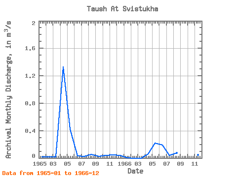
| Year | Jan | Feb | Mar | Apr | May | Jun | Jul | Aug | Sep | Oct | Nov | Dec | Annual | 1965 | 0.02 | 0.02 | 0.02 | 1.33 | 0.42 | 0.03 | 0.03 | 0.05 | 0.02 | 0.04 | 0.04 | 0.04 | 0.17 | 1966 | 0.00 | 0.00 | 0.00 | 0.06 | 0.22 | 0.19 | 0.04 | 0.07 | 0.02 | 0.05 | 0.04 | 0.03 | 0.06 |
|---|
 Return to R-Arctic Net Home Page