|
|
|||||||||||||||||
| Point ID: 8775 | Downloads | Plots | Site Data | Code: 12093 |
|
|
|||||||||||||||||
| Download | |
|---|---|
| Site Descriptor Information | Site Time Series Data |
| Link to all available data | |
| View: | Time Series | All |
| Units: | m3/s |
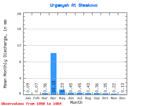
| Statistic | Jan | Feb | Mar | Apr | May | Jun | Jul | Aug | Sep | Oct | Nov | Dec | Annual |
|---|---|---|---|---|---|---|---|---|---|---|---|---|---|
| Mean | 0.09 | 0.07 | 0.36 | 10.05 | 1.22 | 0.44 | 0.45 | 0.42 | 0.36 | 0.34 | 0.22 | 0.13 | 14.34 |
| Standard Deviation | 0.07 | 0.06 | 0.65 | 5.65 | 0.38 | 0.20 | 0.31 | 0.33 | 0.18 | 0.12 | 0.11 | 0.07 | 6.30 |
| Min | 0.03 | 0.00 | 0.00 | 2.82 | 0.66 | 0.19 | 0.10 | 0.10 | 0.10 | 0.19 | 0.06 | 0.03 | 6.51 |
| Max | 0.25 | 0.18 | 2.48 | 22.94 | 1.87 | 0.89 | 1.32 | 1.33 | 0.75 | 0.60 | 0.41 | 0.29 | 28.81 |
| Coefficient of Variation | 0.71 | 0.86 | 1.82 | 0.56 | 0.31 | 0.44 | 0.69 | 0.79 | 0.50 | 0.34 | 0.52 | 0.51 | 0.44 |
 Return to R-Arctic Net Home Page