|
|
|||||||||||||||||
| Point ID: 8766 | Downloads | Plots | Site Data | Code: 12062 |
|
|
|||||||||||||||||
| Download | |
|---|---|
| Site Descriptor Information | Site Time Series Data |
| Link to all available data | |
|
|
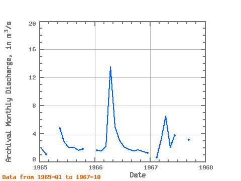
| View: | Statistics | Time Series |
| Units: | mm |
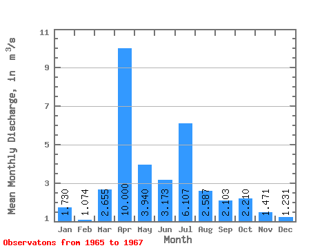
| Statistic | Jan | Feb | Mar | Apr | May | Jun | Jul | Aug | Sep | Oct | Nov | Dec | Annual |
|---|---|---|---|---|---|---|---|---|---|---|---|---|---|
| Mean | 1.73 | 1.07 | 2.66 | 10.00 | 3.94 | 3.17 | 6.11 | 2.59 | 2.10 | 2.21 | 1.47 | 1.23 | 3.06 |
| Standard Deviation | 0.13 | 0.45 | 0.67 | 4.95 | 1.62 | 0.51 | 7.01 | 1.17 | 0.89 | 0.77 | |||
| Min | 1.64 | 0.64 | 2.18 | 6.50 | 2.07 | 2.76 | 2.03 | 1.79 | 1.56 | 1.70 | 1.47 | 1.23 | 3.06 |
| Max | 1.82 | 1.54 | 3.13 | 13.50 | 4.97 | 3.74 | 14.20 | 3.93 | 3.13 | 3.09 | 1.47 | 1.23 | 3.06 |
| Coefficient of Variation | 0.07 | 0.42 | 0.25 | 0.49 | 0.41 | 0.16 | 1.15 | 0.45 | 0.42 | 0.35 |
| Year | Jan | Feb | Mar | Apr | May | Jun | Jul | Aug | Sep | Oct | Nov | Dec | Annual | 1965 | 1.82 | 1.04 | 4.78 | 2.76 | 2.03 | 2.04 | 1.62 | 1.84 | 1966 | 1.64 | 1.54 | 2.18 | 13.50 | 4.97 | 3.02 | 2.09 | 1.79 | 1.56 | 1.70 | 1.47 | 1.23 | 3.06 | 1967 | 0.64 | 3.13 | 6.50 | 2.07 | 3.74 | 14.20 | 3.93 | 3.13 | 3.09 |
|---|
 Return to R-Arctic Net Home Page