|
|
|||||||||||||||||
| Point ID: 8760 | Downloads | Plots | Site Data | Code: 12034 |
|
|
|||||||||||||||||
| Download | |
|---|---|
| Site Descriptor Information | Site Time Series Data |
| Link to all available data | |
|
|
| View: | Statistics | Time Series |
| Units: | mm |
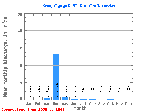
| Statistic | Jan | Feb | Mar | Apr | May | Jun | Jul | Aug | Sep | Oct | Nov | Dec | Annual |
|---|---|---|---|---|---|---|---|---|---|---|---|---|---|
| Mean | 0.06 | 0.03 | 0.47 | 10.70 | 0.60 | 0.31 | 0.16 | 0.20 | 0.11 | 0.16 | 0.14 | 0.01 | 0.72 |
| Standard Deviation | 0.08 | 0.04 | 0.88 | 6.38 | 0.45 | 0.18 | 0.16 | 0.25 | 0.08 | 0.06 | 0.03 | ||
| Min | 0.00 | 0.00 | 0.00 | 2.45 | 0.32 | 0.13 | 0.04 | 0.03 | 0.01 | 0.10 | 0.12 | 0.01 | 0.72 |
| Max | 0.11 | 0.08 | 1.78 | 16.90 | 1.38 | 0.52 | 0.44 | 0.63 | 0.23 | 0.23 | 0.17 | 0.01 | 0.72 |
| Coefficient of Variation | 1.41 | 1.73 | 1.88 | 0.60 | 0.75 | 0.60 | 0.97 | 1.22 | 0.73 | 0.40 | 0.21 |
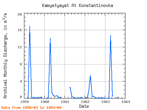
| Year | Jan | Feb | Mar | Apr | May | Jun | Jul | Aug | Sep | Oct | Nov | Dec | Annual | 1959 | 0.00 | 16.90 | 0.32 | 0.13 | 0.14 | 0.14 | 0.12 | 0.23 | 0.17 | 1960 | 0.00 | 0.07 | 14.10 | 1.38 | 0.52 | 0.44 | 0.63 | 0.23 | 0.19 | 1961 | 2.45 | 0.33 | 0.17 | 0.07 | 0.04 | 0.07 | 0.11 | 0.12 | 1962 | 0.11 | 0.08 | 1.78 | 5.36 | 0.40 | 0.49 | 0.13 | 0.03 | 0.01 | 0.10 | 0.12 | 0.01 | 0.72 | 1963 | 0.00 | 0.00 | 0.01 | 14.70 | 0.56 | 0.23 | 0.04 | 0.17 | 0.14 |
|---|
 Return to R-Arctic Net Home Page