|
|
|||||||||||||||||
| Point ID: 8754 | Downloads | Plots | Site Data | Code: 12641 |
|
|
|||||||||||||||||
| Download | |
|---|---|
| Site Descriptor Information | Site Time Series Data |
| Link to all available data | |
|
|
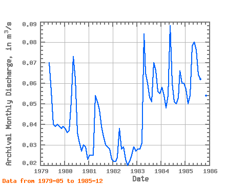
| View: | Statistics | Time Series |
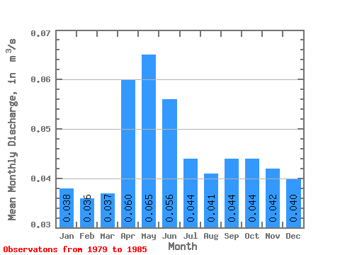
| Units: | mm |
| Statistic | Jan | Feb | Mar | Apr | May | Jun | Jul | Aug | Sep | Oct | Nov | Dec | Annual |
|---|---|---|---|---|---|---|---|---|---|---|---|---|---|
| Mean | 0.04 | 0.04 | 0.04 | 0.06 | 0.07 | 0.06 | 0.04 | 0.04 | 0.04 | 0.04 | 0.04 | 0.04 | 0.05 |
| Standard Deviation | 0.02 | 0.01 | 0.01 | 0.02 | 0.02 | 0.01 | 0.01 | 0.01 | 0.02 | 0.02 | 0.01 | 0.02 | 0.01 |
| Min | 0.02 | 0.02 | 0.02 | 0.04 | 0.03 | 0.03 | 0.02 | 0.02 | 0.02 | 0.03 | 0.03 | 0.02 | 0.03 |
| Max | 0.06 | 0.05 | 0.05 | 0.08 | 0.09 | 0.08 | 0.06 | 0.06 | 0.07 | 0.07 | 0.06 | 0.06 | 0.06 |
| Coefficient of Variation | 0.42 | 0.38 | 0.34 | 0.29 | 0.31 | 0.26 | 0.31 | 0.35 | 0.43 | 0.40 | 0.34 | 0.41 | 0.32 |
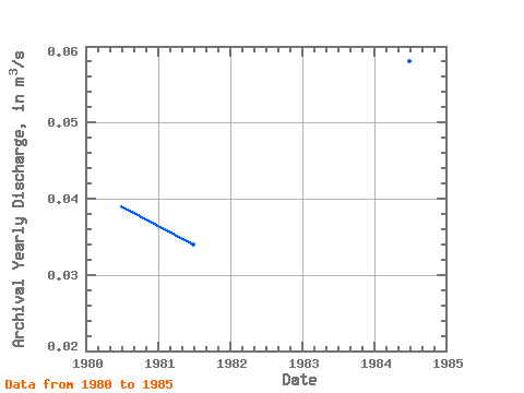
| Year | Jan | Feb | Mar | Apr | May | Jun | Jul | Aug | Sep | Oct | Nov | Dec | Annual | 1979 | 0.07 | 0.06 | 0.04 | 0.04 | 0.04 | 0.04 | 0.04 | 0.04 | 1980 | 0.04 | 0.04 | 0.04 | 0.05 | 0.07 | 0.06 | 0.04 | 0.03 | 0.03 | 0.03 | 0.03 | 0.02 | 0.04 | 1981 | 0.03 | 0.03 | 0.03 | 0.05 | 0.05 | 0.05 | 0.04 | 0.03 | 0.03 | 0.03 | 0.03 | 0.02 | 0.03 | 1982 | 0.02 | 0.02 | 0.02 | 0.04 | 0.03 | 0.03 | 0.02 | 0.02 | 0.02 | 0.03 | 0.03 | 0.03 | 0.03 | 1983 | 0.03 | 0.03 | 0.03 | 0.08 | 0.07 | 0.06 | 0.05 | 0.05 | 0.07 | 0.07 | 0.06 | 0.06 | 0.05 | 1984 | 0.06 | 0.05 | 0.05 | 0.05 | 0.09 | 0.06 | 0.05 | 0.05 | 0.05 | 0.07 | 0.06 | 0.06 | 0.06 | 1985 | 0.06 | 0.05 | 0.05 | 0.08 | 0.08 | 0.08 | 0.06 | 0.06 | 0.06 | 0.06 | 0.05 | 0.06 | 0.06 |
|---|
 Return to R-Arctic Net Home Page