|
|
|||||||||||||||||
| Point ID: 8751 | Downloads | Plots | Site Data | Code: 12637 |
|
|
|||||||||||||||||
| Download | |
|---|---|
| Site Descriptor Information | Site Time Series Data |
| Link to all available data | |
|
|
| View: | Statistics | Time Series |
| Units: | mm |
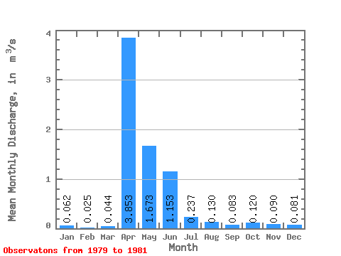
| Statistic | Jan | Feb | Mar | Apr | May | Jun | Jul | Aug | Sep | Oct | Nov | Dec | Annual |
|---|---|---|---|---|---|---|---|---|---|---|---|---|---|
| Mean | 0.06 | 0.03 | 0.04 | 3.85 | 1.67 | 1.15 | 0.24 | 0.13 | 0.08 | 0.12 | 0.09 | 0.08 | 0.58 |
| Standard Deviation | 0.05 | 0.01 | 0.06 | 0.83 | 0.86 | 1.13 | 0.19 | 0.04 | 0.07 | 0.11 | 0.09 | 0.09 | 0.08 |
| Min | 0.03 | 0.02 | 0.01 | 2.90 | 0.72 | 0.34 | 0.10 | 0.10 | 0.00 | 0.00 | 0.00 | 0.00 | 0.53 |
| Max | 0.10 | 0.03 | 0.11 | 4.43 | 2.39 | 2.44 | 0.45 | 0.17 | 0.14 | 0.22 | 0.17 | 0.17 | 0.64 |
| Coefficient of Variation | 0.84 | 0.45 | 1.30 | 0.22 | 0.51 | 0.98 | 0.79 | 0.28 | 0.89 | 0.93 | 0.95 | 1.05 | 0.13 |
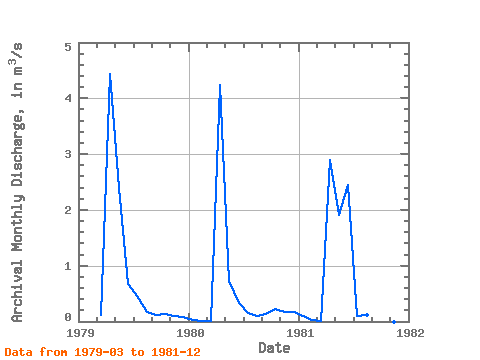
| Year | Jan | Feb | Mar | Apr | May | Jun | Jul | Aug | Sep | Oct | Nov | Dec | Annual | 1979 | 0.11 | 4.43 | 2.39 | 0.68 | 0.45 | 0.17 | 0.11 | 0.14 | 0.10 | 0.07 | 1980 | 0.03 | 0.02 | 0.01 | 4.23 | 0.72 | 0.34 | 0.16 | 0.10 | 0.14 | 0.22 | 0.17 | 0.17 | 0.53 | 1981 | 0.10 | 0.03 | 0.01 | 2.90 | 1.91 | 2.44 | 0.10 | 0.12 | 0.00 | 0.00 | 0.00 | 0.00 | 0.64 |
|---|
 Return to R-Arctic Net Home Page