|
|
|||||||||||||||||
| Point ID: 8750 | Downloads | Plots | Site Data | Code: 12636 |
|
|
|||||||||||||||||
| Download | |
|---|---|
| Site Descriptor Information | Site Time Series Data |
| Link to all available data | |
|
|
| View: | Statistics | Time Series |
| Units: | mm |
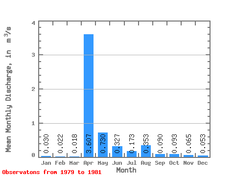
| Statistic | Jan | Feb | Mar | Apr | May | Jun | Jul | Aug | Sep | Oct | Nov | Dec | Annual |
|---|---|---|---|---|---|---|---|---|---|---|---|---|---|
| Mean | 0.03 | 0.02 | 0.02 | 3.61 | 0.73 | 0.33 | 0.17 | 0.35 | 0.09 | 0.09 | 0.07 | 0.05 | 0.41 |
| Standard Deviation | 0.01 | 0.02 | 0.02 | 1.61 | 0.37 | 0.20 | 0.05 | 0.44 | 0.09 | 0.09 | 0.06 | 0.05 | 0.01 |
| Min | 0.02 | 0.01 | 0.00 | 2.03 | 0.35 | 0.20 | 0.14 | 0.09 | 0.00 | 0.00 | 0.00 | 0.00 | 0.40 |
| Max | 0.04 | 0.03 | 0.04 | 5.25 | 1.09 | 0.56 | 0.23 | 0.86 | 0.17 | 0.18 | 0.11 | 0.10 | 0.42 |
| Coefficient of Variation | 0.26 | 0.71 | 1.03 | 0.45 | 0.51 | 0.62 | 0.28 | 1.24 | 0.95 | 0.97 | 0.89 | 0.94 | 0.04 |
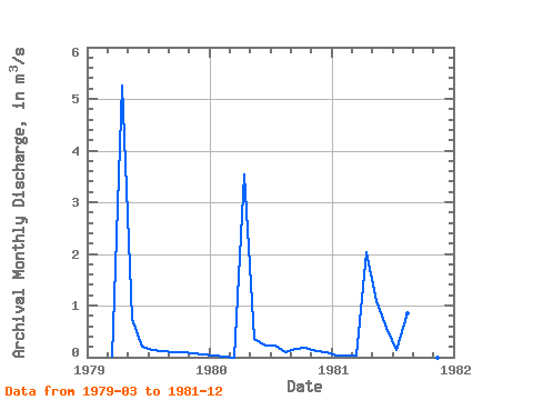
| Year | Jan | Feb | Mar | Apr | May | Jun | Jul | Aug | Sep | Oct | Nov | Dec | Annual | 1979 | 0.02 | 5.25 | 0.75 | 0.20 | 0.15 | 0.11 | 0.10 | 0.10 | 0.09 | 0.06 | 1980 | 0.04 | 0.01 | 0.00 | 3.54 | 0.35 | 0.22 | 0.23 | 0.09 | 0.17 | 0.18 | 0.11 | 0.10 | 0.42 | 1981 | 0.02 | 0.03 | 0.04 | 2.03 | 1.09 | 0.56 | 0.14 | 0.86 | 0.00 | 0.00 | 0.00 | 0.00 | 0.40 |
|---|
 Return to R-Arctic Net Home Page