|
|
|||||||||||||||||
| Point ID: 8737 | Downloads | Plots | Site Data | Code: 12622 |
|
|
|||||||||||||||||
| Download | |
|---|---|
| Site Descriptor Information | Site Time Series Data |
| Link to all available data | |
| View: | Time Series | All |
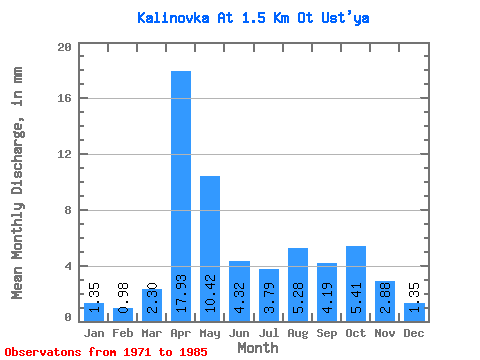
| Units: | m3/s |
| Statistic | Jan | Feb | Mar | Apr | May | Jun | Jul | Aug | Sep | Oct | Nov | Dec | Annual |
|---|---|---|---|---|---|---|---|---|---|---|---|---|---|
| Mean | 1.41 | 1.00 | 2.34 | 17.98 | 10.36 | 4.36 | 3.75 | 5.26 | 4.20 | 5.43 | 2.84 | 1.30 | 60.18 |
| Standard Deviation | 1.13 | 0.94 | 3.68 | 13.99 | 9.60 | 3.39 | 3.17 | 7.24 | 5.35 | 7.22 | 3.19 | 1.02 | 38.24 |
| Min | 0.00 | 0.00 | 0.00 | 1.65 | 0.81 | 0.26 | 0.00 | 0.00 | 0.52 | 0.14 | 0.00 | 0.00 | 7.28 |
| Max | 3.92 | 2.83 | 14.88 | 52.36 | 35.17 | 10.21 | 10.41 | 25.70 | 18.33 | 28.40 | 13.09 | 4.06 | 136.15 |
| Coefficient of Variation | 0.81 | 0.94 | 1.57 | 0.78 | 0.93 | 0.78 | 0.84 | 1.38 | 1.27 | 1.33 | 1.12 | 0.78 | 0.64 |
 Return to R-Arctic Net Home Page