|
|
|||||||||||||||||
| Point ID: 8733 | Downloads | Plots | Site Data | Code: 12618 |
|
|
|||||||||||||||||
| Download | |
|---|---|
| Site Descriptor Information | Site Time Series Data |
| Link to all available data | |
|
|
| View: | Statistics | Time Series |
| Units: | mm |
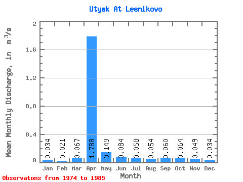
| Statistic | Jan | Feb | Mar | Apr | May | Jun | Jul | Aug | Sep | Oct | Nov | Dec | Annual |
|---|---|---|---|---|---|---|---|---|---|---|---|---|---|
| Mean | 0.03 | 0.02 | 0.07 | 1.79 | 0.15 | 0.08 | 0.06 | 0.05 | 0.06 | 0.06 | 0.05 | 0.03 | 0.20 |
| Standard Deviation | 0.07 | 0.04 | 0.10 | 1.40 | 0.09 | 0.08 | 0.06 | 0.05 | 0.05 | 0.06 | 0.05 | 0.06 | 0.14 |
| Min | 0.00 | 0.00 | 0.00 | 0.37 | 0.06 | 0.01 | 0.01 | 0.01 | 0.01 | 0.01 | 0.00 | 0.00 | 0.04 |
| Max | 0.20 | 0.09 | 0.25 | 4.59 | 0.34 | 0.24 | 0.15 | 0.12 | 0.17 | 0.14 | 0.12 | 0.18 | 0.47 |
| Coefficient of Variation | 2.01 | 1.79 | 1.46 | 0.78 | 0.63 | 0.92 | 0.97 | 0.87 | 0.81 | 0.85 | 0.98 | 1.76 | 0.70 |
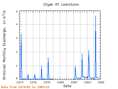
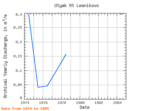
| Year | Jan | Feb | Mar | Apr | May | Jun | Jul | Aug | Sep | Oct | Nov | Dec | Annual | 1974 | 0.00 | 0.00 | 0.00 | 3.28 | 0.07 | 0.06 | 0.02 | 0.02 | 0.04 | 0.04 | 0.03 | 0.00 | 0.29 | 1975 | 0.00 | 0.00 | 0.00 | 0.38 | 0.06 | 0.01 | 0.01 | 0.01 | 0.01 | 0.02 | 0.00 | 0.00 | 0.04 | 1976 | 0.00 | 0.00 | 0.00 | 0.37 | 0.11 | 0.01 | 0.01 | 0.01 | 0.03 | 0.01 | 0.00 | 0.00 | 0.05 | 1977 | 0.00 | 0.00 | 0.01 | 0.97 | 0.06 | 0.03 | 0.02 | 0.04 | 0.05 | 0.02 | 0.00 | 0.00 | 0.10 | 1978 | 0.00 | 0.00 | 0.01 | 1.57 | 0.12 | 0.03 | 0.03 | 0.02 | 0.02 | 0.02 | 0.02 | 0.00 | 0.15 | 1982 | 0.01 | 0.00 | 0.00 | 0.96 | 0.22 | 0.11 | 0.08 | 0.10 | 0.10 | 0.12 | 0.09 | 0.03 | 0.15 | 1983 | 0.10 | 0.09 | 0.14 | 1.86 | 0.21 | 0.24 | 0.15 | 0.12 | 0.17 | 0.14 | 0.12 | 0.18 | 0.29 | 1984 | 0.20 | 0.08 | 0.25 | 2.11 | 0.34 | 0.12 | 0.07 | 0.06 | 0.06 | 0.14 | 0.10 | 0.02 | 0.30 | 1985 | 0.00 | 0.01 | 0.19 | 4.59 | 0.15 | 0.15 | 0.14 | 0.12 | 0.06 | 0.07 | 0.09 | 0.07 | 0.47 |
|---|
 Return to R-Arctic Net Home Page