|
|
|||||||||||||||||
| Point ID: 873 | Downloads | Plots | Site Data | Code: 07EE011 |
|
|
|||||||||||||||||
| Download | |
|---|---|
| Site Descriptor Information | Site Time Series Data |
| Link to all available data | |
|
|
| View: | Statistics | Time Series |
| Units: | mm |
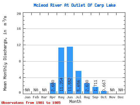
| Statistic | Jan | Feb | Mar | Apr | May | Jun | Jul | Aug | Sep | Oct | Nov | Dec | Annual |
|---|---|---|---|---|---|---|---|---|---|---|---|---|---|
| Mean | 2.68 | 11.35 | 11.55 | 5.66 | 2.63 | 1.71 | 0.67 | ||||||
| Standard Deviation | 3.45 | 3.68 | 1.66 | 0.79 | 0.64 | ||||||||
| Min | 2.68 | 7.83 | 7.16 | 3.86 | 1.77 | 0.80 | 0.67 | ||||||
| Max | 2.68 | 15.80 | 15.70 | 7.80 | 3.40 | 2.29 | 0.67 | ||||||
| Coefficient of Variation | 0.30 | 0.32 | 0.29 | 0.30 | 0.37 |
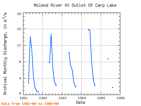
| Year | Jan | Feb | Mar | Apr | May | Jun | Jul | Aug | Sep | Oct | Nov | Dec | Annual | 1981 | 2.68 | 14.10 | 11.20 | 4.11 | 1.78 | 0.80 | 0.67 | 1982 | 7.83 | 14.80 | 6.43 | 3.17 | 2.23 | 1983 | 10.30 | 7.16 | 6.08 | 3.03 | 1.92 | 1984 | 15.80 | 15.70 | 7.80 | 3.40 | 2.29 | 1985 | 8.74 | 8.90 | 3.86 | 1.77 | 1.31 |
|---|
 Return to R-Arctic Net Home Page