|
|
|||||||||||||||||
| Point ID: 8728 | Downloads | Plots | Site Data | Code: 12556 |
|
|
|||||||||||||||||
| Download | |
|---|---|
| Site Descriptor Information | Site Time Series Data |
| Link to all available data | |
|
|
| View: | Statistics | Time Series |
| Units: | mm |
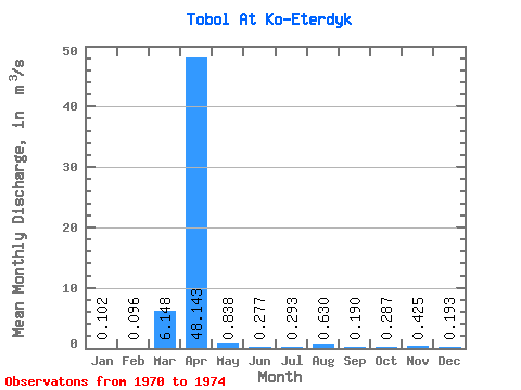
| Statistic | Jan | Feb | Mar | Apr | May | Jun | Jul | Aug | Sep | Oct | Nov | Dec | Annual |
|---|---|---|---|---|---|---|---|---|---|---|---|---|---|
| Mean | 0.10 | 0.10 | 6.15 | 48.14 | 0.84 | 0.28 | 0.29 | 0.63 | 0.19 | 0.29 | 0.42 | 0.19 | 6.27 |
| Standard Deviation | 0.04 | 0.11 | 11.57 | 53.63 | 0.55 | 0.20 | 0.23 | 0.97 | 0.04 | 0.03 | 0.25 | 0.06 | |
| Min | 0.06 | 0.00 | 0.18 | 1.71 | 0.28 | 0.05 | 0.12 | 0.06 | 0.17 | 0.26 | 0.25 | 0.13 | 6.27 |
| Max | 0.16 | 0.25 | 23.50 | 113.00 | 1.50 | 0.41 | 0.56 | 1.75 | 0.23 | 0.32 | 0.60 | 0.23 | 6.27 |
| Coefficient of Variation | 0.41 | 1.16 | 1.88 | 1.11 | 0.66 | 0.71 | 0.80 | 1.54 | 0.18 | 0.11 | 0.58 | 0.28 |
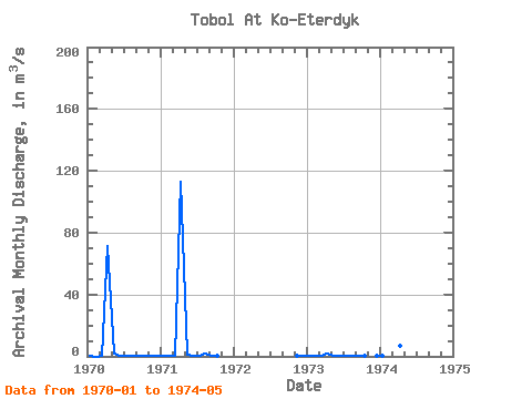
| Year | Jan | Feb | Mar | Apr | May | Jun | Jul | Aug | Sep | Oct | Nov | Dec | Annual | 1970 | 0.06 | 0.00 | 0.46 | 71.30 | 1.50 | 0.41 | 0.12 | 0.06 | 0.23 | 0.28 | 0.60 | 0.22 | 6.27 | 1971 | 0.09 | 0.03 | 0.18 | 113.00 | 1.07 | 0.37 | 0.20 | 1.75 | 0.17 | 0.26 | 1972 | 0.25 | 0.23 | 1973 | 0.16 | 0.25 | 0.45 | 1.71 | 0.50 | 0.05 | 0.56 | 0.08 | 0.17 | 0.32 | 0.13 | 1974 | 0.10 | 0.10 | 23.50 | 6.56 | 0.28 |
|---|
 Return to R-Arctic Net Home Page