|
|
|||||||||||||||||
| Point ID: 8727 | Downloads | Plots | Site Data | Code: 12555 |
|
|
|||||||||||||||||
| Download | |
|---|---|
| Site Descriptor Information | Site Time Series Data |
| Link to all available data | |
|
|
| View: | Statistics | Time Series |
| Units: | mm |
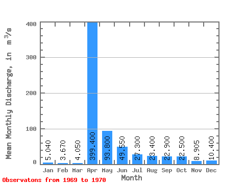
| Statistic | Jan | Feb | Mar | Apr | May | Jun | Jul | Aug | Sep | Oct | Nov | Dec | Annual |
|---|---|---|---|---|---|---|---|---|---|---|---|---|---|
| Mean | 5.04 | 3.67 | 4.05 | 399.40 | 93.80 | 49.55 | 27.30 | 23.40 | 22.90 | 22.50 | 8.90 | 10.40 | 88.53 |
| Standard Deviation | 2.55 | 2.76 | 3.28 | 451.98 | 39.88 | 33.02 | 9.76 | 10.32 | 0.00 | ||||
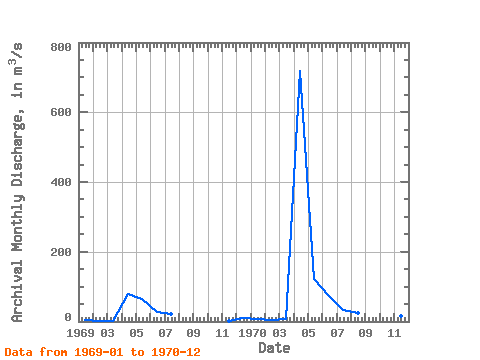
| Min | 3.24 | 1.72 | 1.73 | 79.80 | 65.60 | 26.20 | 20.40 | 23.40 | 22.90 | 22.50 | 1.61 | 10.40 | 88.53 |
| Max | 6.84 | 5.62 | 6.37 | 719.00 | 122.00 | 72.90 | 34.20 | 23.40 | 22.90 | 22.50 | 16.20 | 10.40 | 88.53 |
| Coefficient of Variation | 0.51 | 0.75 | 0.81 | 1.13 | 0.42 | 0.67 | 0.36 | 1.16 | 0.00 |
| Year | Jan | Feb | Mar | Apr | May | Jun | Jul | Aug | Sep | Oct | Nov | Dec | Annual | 1969 | 3.24 | 1.72 | 1.73 | 79.80 | 65.60 | 26.20 | 20.40 | 1.61 | 10.40 | 1970 | 6.84 | 5.62 | 6.37 | 719.00 | 122.00 | 72.90 | 34.20 | 23.40 | 22.90 | 22.50 | 16.20 | 10.40 | 88.53 |
|---|
 Return to R-Arctic Net Home Page