|
|
|||||||||||||||||
| Point ID: 8718 | Downloads | Plots | Site Data | Code: 12467 |
|
|
|||||||||||||||||
| Download | |
|---|---|
| Site Descriptor Information | Site Time Series Data |
| Link to all available data | |
| View: | Time Series | All |
| Units: | m3/s |
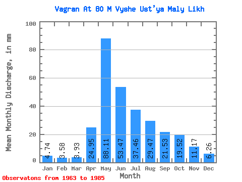
| Statistic | Jan | Feb | Mar | Apr | May | Jun | Jul | Aug | Sep | Oct | Nov | Dec | Annual |
|---|---|---|---|---|---|---|---|---|---|---|---|---|---|
| Mean | 4.73 | 3.61 | 3.93 | 24.95 | 88.10 | 53.47 | 37.45 | 29.46 | 21.53 | 19.52 | 11.17 | 6.26 | 299.41 |
| Standard Deviation | 1.87 | 1.63 | 1.61 | 19.02 | 47.59 | 30.74 | 25.97 | 22.80 | 13.15 | 12.00 | 5.99 | 2.87 | 82.91 |
| Min | 0.55 | 0.32 | 0.16 | 4.46 | 25.94 | 20.25 | 8.05 | 9.53 | 8.44 | 6.12 | 4.21 | -1.93 | 197.88 |
| Max | 8.85 | 6.25 | 6.66 | 57.95 | 230.14 | 132.40 | 125.53 | 90.77 | 63.87 | 50.21 | 30.75 | 11.94 | 503.75 |
| Coefficient of Variation | 0.40 | 0.45 | 0.41 | 0.76 | 0.54 | 0.57 | 0.69 | 0.77 | 0.61 | 0.61 | 0.54 | 0.46 | 0.28 |
 Return to R-Arctic Net Home Page