|
|
|||||||||||||||||
| Point ID: 8717 | Downloads | Plots | Site Data | Code: 12466 |
|
|
|||||||||||||||||
| Download | |
|---|---|
| Site Descriptor Information | Site Time Series Data |
| Link to all available data | |
|
|
| View: | Statistics | Time Series |
| Units: | mm |
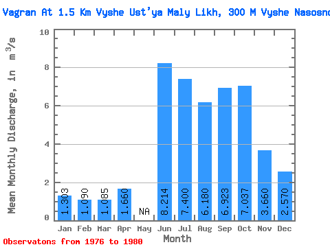
| Statistic | Jan | Feb | Mar | Apr | May | Jun | Jul | Aug | Sep | Oct | Nov | Dec | Annual |
|---|---|---|---|---|---|---|---|---|---|---|---|---|---|
| Mean | 1.30 | 1.09 | 1.08 | 1.66 | 8.21 | 7.40 | 6.18 | 6.92 | 7.04 | 3.66 | 2.57 | ||
| Standard Deviation | 0.84 | 0.68 | 0.55 | 2.21 | 4.42 | 3.19 | 3.74 | 6.08 | 3.03 | 1.03 | |||
| Min | 0.17 | 0.11 | 0.30 | 1.66 | 6.10 | 2.60 | 3.20 | 2.60 | 2.04 | 1.52 | 1.21 | ||
| Max | 2.17 | 1.55 | 1.50 | 1.66 | 10.50 | 11.30 | 10.60 | 9.10 | 13.80 | 5.80 | 3.71 | ||
| Coefficient of Variation | 0.65 | 0.62 | 0.51 | 0.27 | 0.60 | 0.52 | 0.54 | 0.86 | 0.83 | 0.40 |
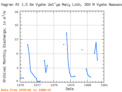
| Year | Jan | Feb | Mar | Apr | May | Jun | Jul | Aug | Sep | Oct | Nov | Dec | Annual | 1976 | 1.25 | 1.15 | 1.10 | 10.50 | 8.30 | 3.20 | 2.60 | 2.04 | 1.52 | 1.21 | 1977 | 0.17 | 0.11 | 0.30 | 6.10 | 2.60 | 4.72 | 1978 | 10.60 | 13.80 | 5.80 | 2.80 | 1979 | 1.62 | 1.55 | 1.50 | 1.66 | 9.07 | 3.71 | 1980 | 2.17 | 1.55 | 1.44 | 8.04 | 11.30 | 6.20 | 9.10 | 5.27 | 2.56 |
|---|
 Return to R-Arctic Net Home Page