|
|
|||||||||||||||||
| Point ID: 8716 | Downloads | Plots | Site Data | Code: 12463 |
|
|
|||||||||||||||||
| Download | |
|---|---|
| Site Descriptor Information | Site Time Series Data |
| Link to all available data | |
| View: | Time Series | All |
| Units: | m3/s |
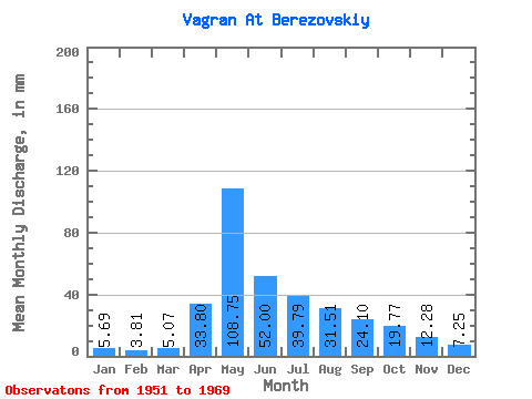
| Statistic | Jan | Feb | Mar | Apr | May | Jun | Jul | Aug | Sep | Oct | Nov | Dec | Annual |
|---|---|---|---|---|---|---|---|---|---|---|---|---|---|
| Mean | 5.69 | 3.85 | 5.07 | 33.80 | 108.73 | 52.00 | 39.79 | 31.50 | 24.10 | 19.77 | 12.28 | 7.25 | 331.98 |
| Standard Deviation | 1.24 | 1.23 | 2.73 | 24.58 | 59.69 | 23.68 | 24.57 | 32.62 | 20.71 | 9.17 | 5.93 | 2.21 | 96.73 |
| Min | 3.82 | 1.14 | 3.32 | 3.54 | 37.66 | 23.35 | 12.95 | 8.47 | 9.72 | 10.21 | 5.06 | 3.28 | 193.44 |
| Max | 8.05 | 7.07 | 15.36 | 80.77 | 259.91 | 113.33 | 106.70 | 124.56 | 84.79 | 50.24 | 28.17 | 12.87 | 554.83 |
| Coefficient of Variation | 0.22 | 0.32 | 0.54 | 0.73 | 0.55 | 0.46 | 0.62 | 1.03 | 0.86 | 0.46 | 0.48 | 0.30 | 0.29 |
 Return to R-Arctic Net Home Page