|
|
|||||||||||||||||
| Point ID: 8689 | Downloads | Plots | Site Data | Code: 11606 |
|
|
|||||||||||||||||
| Download | |
|---|---|
| Site Descriptor Information | Site Time Series Data |
| Link to all available data | |
| View: | Time Series | All |
| Units: | mm |
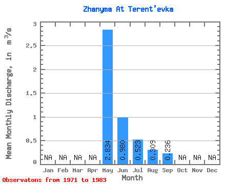
| Statistic | Jan | Feb | Mar | Apr | May | Jun | Jul | Aug | Sep | Oct | Nov | Dec | Annual |
|---|---|---|---|---|---|---|---|---|---|---|---|---|---|
| Mean | 2.83 | 0.98 | 0.52 | 0.31 | 0.24 | ||||||||
| Standard Deviation | 2.17 | 0.70 | 0.36 | 0.16 | 0.12 | ||||||||
| Min | 0.44 | 0.12 | 0.09 | 0.09 | 0.10 | ||||||||
| Max | 7.09 | 2.33 | 1.29 | 0.62 | 0.37 | ||||||||
| Coefficient of Variation | 0.77 | 0.71 | 0.69 | 0.51 | 0.52 |
 Return to R-Arctic Net Home Page