|
|
|||||||||||||||||
| Point ID: 8689 | Downloads | Plots | Site Data | Code: 11606 |
|
|
|||||||||||||||||
| Download | |
|---|---|
| Site Descriptor Information | Site Time Series Data |
| Link to all available data | |
| View: | Time Series | All |
| Units: | m3/s |
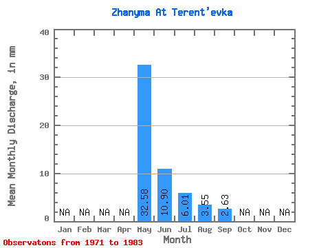
| Statistic | Jan | Feb | Mar | Apr | May | Jun | Jul | Aug | Sep | Oct | Nov | Dec | Annual |
|---|---|---|---|---|---|---|---|---|---|---|---|---|---|
| Mean | 32.57 | 10.90 | 6.01 | 3.55 | 2.62 | ||||||||
| Standard Deviation | 24.97 | 7.76 | 4.18 | 1.82 | 1.37 | ||||||||
| Min | 5.06 | 1.33 | 1.06 | 1.02 | 1.11 | ||||||||
| Max | 81.49 | 25.92 | 14.83 | 7.13 | 4.12 | ||||||||
| Coefficient of Variation | 0.77 | 0.71 | 0.69 | 0.51 | 0.52 |
 Return to R-Arctic Net Home Page