|
|
|||||||||||||||||
| Point ID: 8687 | Downloads | Plots | Site Data | Code: 11604 |
|
|
|||||||||||||||||
| Download | |
|---|---|
| Site Descriptor Information | Site Time Series Data |
| Link to all available data | |
|
|
| View: | Statistics | Time Series |
| Units: | mm |
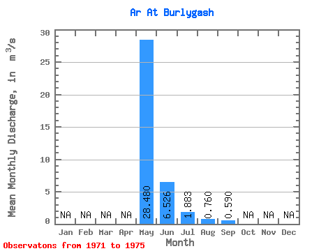
| Statistic | Jan | Feb | Mar | Apr | May | Jun | Jul | Aug | Sep | Oct | Nov | Dec | Annual |
|---|---|---|---|---|---|---|---|---|---|---|---|---|---|
| Mean | 28.48 | 6.53 | 1.88 | 0.76 | 0.59 | ||||||||
| Standard Deviation | 21.85 | 5.51 | 2.71 | 0.65 | 0.18 | ||||||||
| Min | 1.80 | 0.22 | 0.14 | 0.11 | 0.46 | ||||||||
| Max | 59.60 | 14.20 | 5.90 | 1.62 | 0.72 | ||||||||
| Coefficient of Variation | 0.77 | 0.84 | 1.44 | 0.85 | 0.31 |
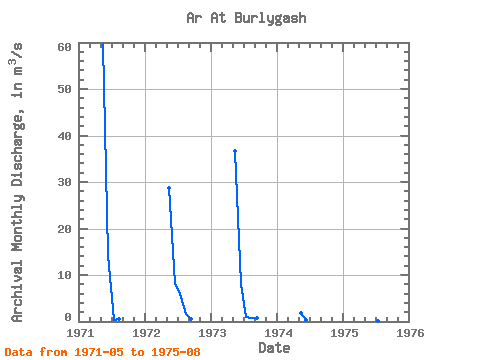
| Year | Jan | Feb | Mar | Apr | May | Jun | Jul | Aug | Sep | Oct | Nov | Dec | Annual | 1971 | 59.60 | 14.20 | 0.42 | 0.46 | 1972 | 28.70 | 7.99 | 5.90 | 1.62 | 0.46 | 1973 | 36.60 | 8.00 | 1.07 | 0.85 | 0.72 | 1974 | 1.80 | 0.22 | 1975 | 15.70 | 2.22 | 0.14 | 0.11 |
|---|
 Return to R-Arctic Net Home Page