|
|
|||||||||||||||||
| Point ID: 8673 | Downloads | Plots | Site Data | Code: 11559 |
|
|
|||||||||||||||||
| Download | |
|---|---|
| Site Descriptor Information | Site Time Series Data |
| Link to all available data | |
|
|
| View: | Statistics | Time Series |
| Units: | mm |
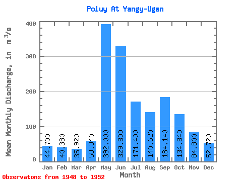
| Statistic | Jan | Feb | Mar | Apr | May | Jun | Jul | Aug | Sep | Oct | Nov | Dec | Annual |
|---|---|---|---|---|---|---|---|---|---|---|---|---|---|
| Mean | 44.70 | 40.38 | 35.92 | 58.34 | 392.00 | 329.80 | 171.40 | 140.62 | 184.14 | 134.84 | 84.80 | 52.72 | 139.14 |
| Standard Deviation | 7.54 | 5.09 | 3.62 | 45.12 | 147.59 | 135.58 | 37.98 | 34.47 | 94.67 | 70.88 | 26.13 | 14.64 | 18.65 |
| Min | 36.70 | 35.80 | 32.00 | 35.90 | 157.00 | 213.00 | 127.00 | 96.10 | 84.70 | 74.80 | 47.10 | 28.20 | 115.11 |
| Max | 55.20 | 48.20 | 40.50 | 139.00 | 563.00 | 558.00 | 216.00 | 175.00 | 317.00 | 250.00 | 115.00 | 66.70 | 162.82 |
| Coefficient of Variation | 0.17 | 0.13 | 0.10 | 0.77 | 0.38 | 0.41 | 0.22 | 0.24 | 0.51 | 0.53 | 0.31 | 0.28 | 0.13 |
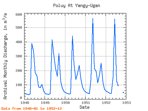
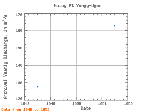
| Year | Jan | Feb | Mar | Apr | May | Jun | Jul | Aug | Sep | Oct | Nov | Dec | Annual | 1948 | 36.70 | 36.40 | 32.00 | 35.90 | 388.00 | 332.00 | 184.00 | 163.00 | 84.70 | 80.40 | 103.00 | 55.20 | 127.61 | 1949 | 38.60 | 35.80 | 32.60 | 37.70 | 413.00 | 299.00 | 216.00 | 157.00 | 317.00 | 123.00 | 77.40 | 53.40 | 150.04 | 1950 | 44.30 | 39.10 | 36.40 | 39.90 | 439.00 | 247.00 | 137.00 | 175.00 | 236.00 | 146.00 | 81.50 | 60.10 | 140.11 | 1951 | 48.70 | 42.40 | 38.10 | 139.00 | 563.00 | 213.00 | 193.00 | 112.00 | 173.00 | 250.00 | 115.00 | 66.70 | 162.82 | 1952 | 55.20 | 48.20 | 40.50 | 39.20 | 157.00 | 558.00 | 127.00 | 96.10 | 110.00 | 74.80 | 47.10 | 28.20 | 115.11 |
|---|
 Return to R-Arctic Net Home Page