|
|
|||||||||||||||||
| Point ID: 867 | Downloads | Plots | Site Data | Code: 07EE003 |
|
|
|||||||||||||||||
| Download | |
|---|---|
| Site Descriptor Information | Site Time Series Data |
| Link to all available data | |
|
|
| View: | Statistics | Time Series |
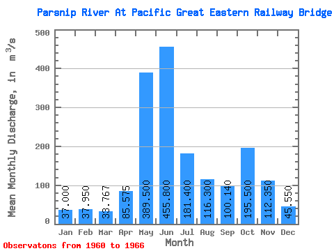
| Units: | mm |
| Statistic | Jan | Feb | Mar | Apr | May | Jun | Jul | Aug | Sep | Oct | Nov | Dec | Annual |
|---|---|---|---|---|---|---|---|---|---|---|---|---|---|
| Mean | 37.00 | 37.95 | 33.77 | 85.58 | 389.50 | 455.80 | 181.40 | 116.30 | 100.14 | 195.50 | 112.35 | 45.55 | 134.46 |
| Standard Deviation | 7.78 | 6.43 | 4.43 | 29.16 | 66.14 | 174.93 | 81.06 | 88.38 | 48.25 | 23.64 | 50.27 | 1.77 | |
| Min | 31.50 | 33.40 | 29.90 | 60.10 | 288.00 | 346.00 | 101.00 | 37.20 | 31.20 | 174.00 | 60.10 | 44.30 | 134.46 |
| Max | 42.50 | 42.50 | 38.60 | 119.00 | 484.00 | 766.00 | 315.00 | 236.00 | 144.00 | 228.00 | 173.00 | 46.80 | 134.46 |
| Coefficient of Variation | 0.21 | 0.17 | 0.13 | 0.34 | 0.17 | 0.38 | 0.45 | 0.76 | 0.48 | 0.12 | 0.45 | 0.04 |
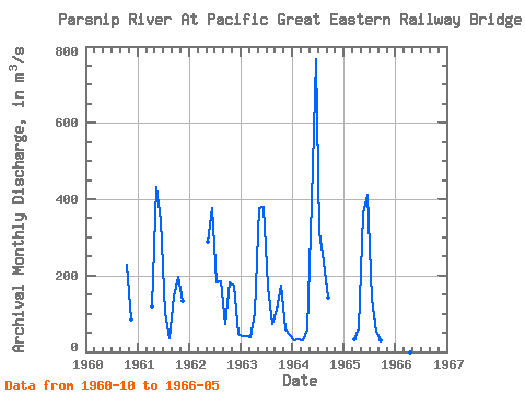
| Year | Jan | Feb | Mar | Apr | May | Jun | Jul | Aug | Sep | Oct | Nov | Dec | Annual | 1960 | 228.00 | 84.30 | 1961 | 119.00 | 431.00 | 346.00 | 101.00 | 37.20 | 144.00 | 197.00 | 132.00 | 1962 | 288.00 | 377.00 | 181.00 | 184.00 | 72.50 | 183.00 | 173.00 | 46.80 | 1963 | 42.50 | 42.50 | 38.60 | 101.00 | 376.00 | 379.00 | 172.00 | 72.50 | 111.00 | 174.00 | 60.10 | 44.30 | 134.46 | 1964 | 31.50 | 33.40 | 29.90 | 60.10 | 395.00 | 766.00 | 315.00 | 236.00 | 142.00 | 1965 | 32.80 | 62.20 | 363.00 | 411.00 | 138.00 | 51.80 | 31.20 | 1966 | 484.00 |
|---|
 Return to R-Arctic Net Home Page