|
|
|||||||||||||||||
| Point ID: 8654 | Downloads | Plots | Site Data | Code: 11459 |
|
|
|||||||||||||||||
| Download | |
|---|---|
| Site Descriptor Information | Site Time Series Data |
| Link to all available data | |
|
|
| View: | Statistics | Time Series |
| Units: | mm |
| Statistic | Jan | Feb | Mar | Apr | May | Jun | Jul | Aug | Sep | Oct | Nov | Dec | Annual |
|---|---|---|---|---|---|---|---|---|---|---|---|---|---|
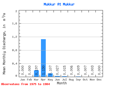
| Mean | 0.00 | 0.00 | 0.20 | 1.13 | 0.11 | 0.03 | 0.01 | 0.01 | 0.01 | 0.01 | 0.00 | 0.00 | 0.14 |
| Standard Deviation | 0.00 | 0.00 | 0.52 | 0.41 | 0.11 | 0.03 | 0.01 | 0.01 | 0.01 | 0.01 | 0.00 | 0.00 | 0.04 |
| Min | 0.00 | 0.00 | 0.00 | 0.68 | 0.03 | 0.00 | 0.00 | 0.00 | 0.00 | 0.00 | 0.00 | 0.00 | 0.08 |
| Max | 0.00 | 0.00 | 1.38 | 1.77 | 0.27 | 0.07 | 0.04 | 0.02 | 0.02 | 0.02 | 0.01 | 0.00 | 0.18 |
| Coefficient of Variation | 2.65 | 0.37 | 1.05 | 0.97 | 1.04 | 0.96 | 0.94 | 0.96 | 1.19 | 2.65 | 0.28 |
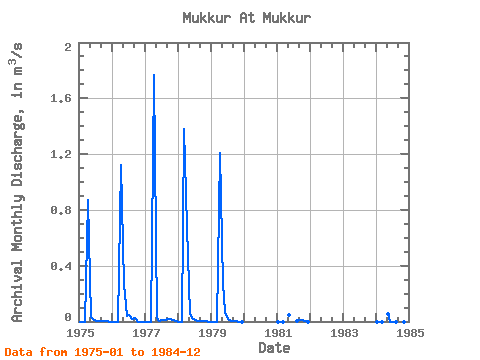
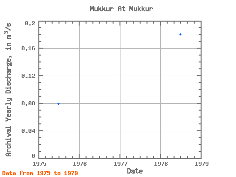
| Year | Jan | Feb | Mar | Apr | May | Jun | Jul | Aug | Sep | Oct | Nov | Dec | Annual | 1975 | 0.00 | 0.00 | 0.00 | 0.87 | 0.03 | 0.02 | 0.01 | 0.00 | 0.00 | 0.01 | 0.00 | 0.00 | 0.08 | 1976 | 0.00 | 0.00 | 0.00 | 1.12 | 0.27 | 0.04 | 0.04 | 0.02 | 0.02 | 0.00 | 0.00 | 0.00 | 0.13 | 1977 | 0.00 | 0.00 | 0.00 | 1.77 | 0.03 | 0.00 | 0.01 | 0.01 | 0.02 | 0.02 | 0.01 | 0.00 | 0.16 | 1978 | 0.00 | 0.00 | 1.38 | 0.68 | 0.05 | 0.03 | 0.01 | 0.00 | 0.00 | 0.01 | 0.00 | 0.00 | 0.18 | 1979 | 0.00 | 0.00 | 0.00 | 1.21 | 0.27 | 0.07 | 0.02 | 0.01 | 0.01 | 0.01 | 0.00 | 0.00 | 0.13 | 1981 | 0.00 | 0.00 | 0.00 | 0.04 | 0.01 | 0.01 | 0.01 | 0.01 | 0.00 | 1984 | 0.00 | 0.00 | 0.00 | 0.05 | 0.00 | 0.00 | 0.00 | 0.00 | 0.00 | 0.00 | 0.00 |
|---|
 Return to R-Arctic Net Home Page