|
|
|||||||||||||||||
| Point ID: 865 | Downloads | Plots | Site Data | Code: 07ED003 |
|
|
|||||||||||||||||
| Download | |
|---|---|
| Site Descriptor Information | Site Time Series Data |
| Link to all available data | |
|
|
| View: | Statistics | Time Series |
| Units: | mm |
| Statistic | Jan | Feb | Mar | Apr | May | Jun | Jul | Aug | Sep | Oct | Nov | Dec | Annual |
|---|---|---|---|---|---|---|---|---|---|---|---|---|---|
| Mean | 23.00 | 19.16 | 19.43 | 46.64 | 279.45 | 295.95 | 105.92 | 40.95 | 30.11 | 37.88 | 41.60 | 29.11 | 80.77 |
| Standard Deviation | 5.42 | 3.53 | 5.42 | 27.67 | 77.13 | 110.32 | 37.55 | 16.08 | 12.76 | 16.14 | 17.52 | 7.23 | 16.66 |
| Min | 14.20 | 13.20 | 14.10 | 16.30 | 139.00 | 144.00 | 50.60 | 23.00 | 13.80 | 17.60 | 19.50 | 13.90 | 55.40 |
| Max | 39.00 | 26.20 | 35.30 | 135.00 | 460.00 | 500.00 | 197.00 | 74.40 | 60.80 | 66.30 | 87.90 | 41.00 | 119.56 |
| Coefficient of Variation | 0.24 | 0.18 | 0.28 | 0.59 | 0.28 | 0.37 | 0.35 | 0.39 | 0.42 | 0.43 | 0.42 | 0.25 | 0.21 |
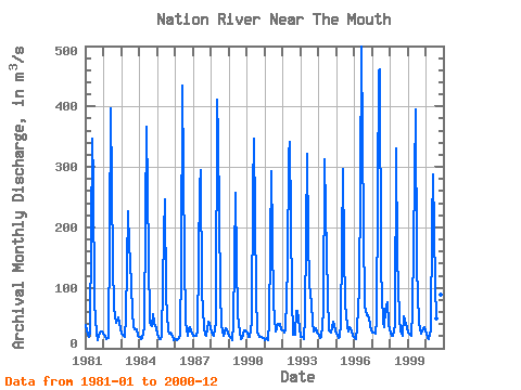
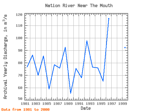
| Year | Jan | Feb | Mar | Apr | May | Jun | Jul | Aug | Sep | Oct | Nov | Dec | Annual | 1981 | 39.00 | 23.00 | 18.50 | 27.20 | 347.00 | 276.00 | 74.10 | 25.70 | 13.80 | 20.40 | 27.70 | 28.00 | 76.70 | 1982 | 22.60 | 18.20 | 16.00 | 16.30 | 183.00 | 397.00 | 140.00 | 67.90 | 42.30 | 45.60 | 51.90 | 33.40 | 86.18 | 1983 | 24.60 | 20.90 | 19.00 | 51.50 | 227.00 | 172.00 | 144.00 | 62.10 | 34.60 | 31.70 | 30.70 | 20.70 | 69.90 | 1984 | 18.00 | 15.20 | 16.70 | 34.10 | 214.00 | 366.00 | 151.00 | 42.60 | 36.40 | 56.30 | 41.50 | 32.90 | 85.39 | 1985 | 21.60 | 15.60 | 14.70 | 20.20 | 189.00 | 247.00 | 87.20 | 27.80 | 23.60 | 25.20 | 20.00 | 13.90 | 58.82 | 1986 | 15.10 | 13.20 | 15.40 | 20.10 | 139.00 | 434.00 | 150.00 | 41.80 | 20.00 | 32.90 | 34.50 | 24.90 | 78.41 | 1987 | 21.30 | 21.20 | 19.80 | 28.00 | 268.00 | 294.00 | 91.80 | 35.10 | 21.90 | 21.40 | 44.40 | 41.00 | 75.66 | 1988 | 26.60 | 22.70 | 19.90 | 44.20 | 412.00 | 349.00 | 94.00 | 37.90 | 20.50 | 25.60 | 32.30 | 25.80 | 92.54 | 1989 | 20.30 | 16.30 | 14.10 | 39.30 | 258.00 | 144.00 | 55.00 | 25.90 | 15.00 | 17.60 | 29.90 | 29.40 | 55.40 | 1990 | 25.10 | 18.50 | 19.20 | 44.80 | 262.00 | 346.00 | 88.30 | 27.20 | 18.60 | 18.90 | 19.50 | 17.60 | 75.47 | 1991 | 14.20 | 17.20 | 14.30 | 44.70 | 293.00 | 184.00 | 75.00 | 27.30 | 33.80 | 41.00 | 40.50 | 30.70 | 67.97 | 1992 | 29.10 | 26.20 | 31.40 | 135.00 | 321.00 | 342.00 | 84.70 | 23.00 | 22.50 | 62.60 | 62.00 | 33.20 | 97.72 | 1993 | 19.10 | 18.40 | 15.90 | 52.00 | 321.00 | 182.00 | 106.00 | 74.40 | 42.80 | 27.60 | 32.90 | 25.20 | 76.44 | 1994 | 22.80 | 17.80 | 19.30 | 60.90 | 313.00 | 226.00 | 87.70 | 30.10 | 25.50 | 35.30 | 44.00 | 29.90 | 76.03 | 1995 | 23.80 | 17.60 | 18.10 | 41.90 | 296.00 | 163.00 | 73.00 | 37.40 | 26.90 | 34.60 | 29.30 | 20.10 | 65.14 | 1996 | 17.20 | 15.60 | 35.30 | 98.20 | 267.00 | 500.00 | 197.00 | 69.90 | 55.30 | 54.10 | 48.60 | 30.40 | 115.72 | 1997 | 25.40 | 25.40 | 24.00 | 47.00 | 460.00 | 462.00 | 131.00 | 43.70 | 35.70 | 63.10 | 76.50 | 40.90 | 119.56 | 1998 | 24.80 | 20.10 | 20.20 | 38.10 | 330.00 | 151.00 | 50.60 | 26.90 | 21.20 | 52.40 | 46.10 | 34.10 | 67.96 | 1999 | 26.20 | 22.90 | 20.70 | 59.70 | 283.00 | 396.00 | 134.00 | 43.20 | 31.00 | 25.00 | 31.80 | 34.90 | 92.37 | 2000 | 23.30 | 17.20 | 16.00 | 29.60 | 206.00 | 288.00 | 104.00 | 49.00 | 60.80 | 66.30 | 87.90 | 35.30 | 81.95 |
|---|
 Return to R-Arctic Net Home Page
