|
|
|||||||||||||||||
| Point ID: 8631 | Downloads | Plots | Site Data | Code: 11305 |
|
|
|||||||||||||||||
| Download | |
|---|---|
| Site Descriptor Information | Site Time Series Data |
| Link to all available data | |
| View: | Time Series | All |
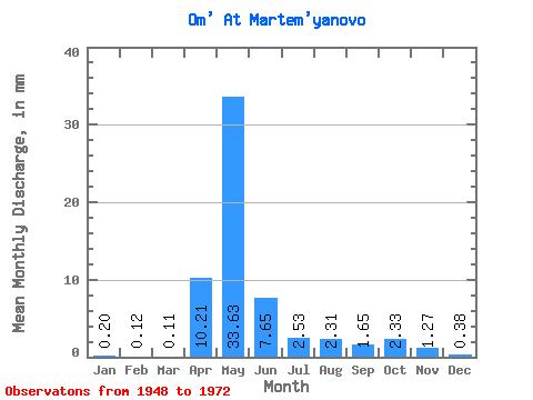
| Units: | m3/s |
| Statistic | Jan | Feb | Mar | Apr | May | Jun | Jul | Aug | Sep | Oct | Nov | Dec | Annual |
|---|---|---|---|---|---|---|---|---|---|---|---|---|---|
| Mean | 0.20 | 0.12 | 0.10 | 10.21 | 33.63 | 7.66 | 2.53 | 2.31 | 1.65 | 2.33 | 1.27 | 0.38 | 54.17 |
| Standard Deviation | 0.20 | 0.11 | 0.08 | 10.64 | 25.48 | 6.52 | 2.96 | 3.96 | 2.27 | 2.86 | 1.74 | 0.47 | 35.06 |
| Min | 0.02 | 0.01 | 0.02 | 0.58 | 0.85 | 0.47 | 0.16 | 0.12 | 0.06 | 0.05 | 0.05 | 0.04 | 5.67 |
| Max | 0.84 | 0.38 | 0.30 | 39.19 | 101.70 | 25.64 | 11.04 | 17.34 | 7.22 | 10.17 | 7.22 | 2.00 | 130.51 |
| Coefficient of Variation | 1.00 | 0.91 | 0.79 | 1.04 | 0.76 | 0.85 | 1.17 | 1.72 | 1.38 | 1.23 | 1.37 | 1.23 | 0.65 |
 Return to R-Arctic Net Home Page