|
|
|||||||||||||||||
| Point ID: 8611 | Downloads | Plots | Site Data | Code: 11227 |
|
|
|||||||||||||||||
| Download | |
|---|---|
| Site Descriptor Information | Site Time Series Data |
| Link to all available data | |
| View: | Time Series | All |
| Units: | m3/s |
| Statistic | Jan | Feb | Mar | Apr | May | Jun | Jul | Aug | Sep | Oct | Nov | Dec | Annual |
|---|---|---|---|---|---|---|---|---|---|---|---|---|---|
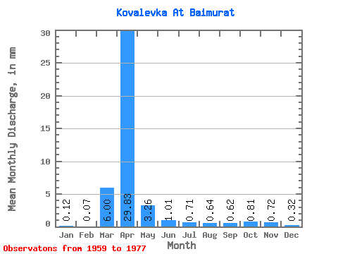
| Mean | 0.12 | 0.07 | 6.00 | 29.83 | 3.26 | 1.01 | 0.70 | 0.64 | 0.62 | 0.81 | 0.72 | 0.32 | 30.48 |
| Standard Deviation | 0.26 | 0.24 | 9.70 | 31.47 | 2.49 | 0.77 | 0.63 | 0.53 | 0.34 | 0.34 | 0.46 | 0.49 | 17.45 |
| Min | 0.00 | 0.00 | 0.00 | 2.40 | 0.61 | 0.23 | 0.13 | 0.12 | 0.21 | 0.37 | 0.15 | 0.00 | 7.73 |
| Max | 0.82 | 0.75 | 31.06 | 127.06 | 7.88 | 2.47 | 1.96 | 2.03 | 1.38 | 1.43 | 1.60 | 1.43 | 54.00 |
| Coefficient of Variation | 2.15 | 3.16 | 1.62 | 1.05 | 0.76 | 0.76 | 0.90 | 0.83 | 0.55 | 0.43 | 0.64 | 1.54 | 0.57 |
 Return to R-Arctic Net Home Page