|
|
|||||||||||||||||
| Point ID: 8585 | Downloads | Plots | Site Data | Code: 11168 |
|
|
|||||||||||||||||
| Download | |
|---|---|
| Site Descriptor Information | Site Time Series Data |
| Link to all available data | |
| View: | Time Series | All |
| Units: | m3/s |
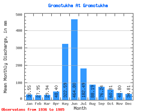
| Statistic | Jan | Feb | Mar | Apr | May | Jun | Jul | Aug | Sep | Oct | Nov | Dec | Annual |
|---|---|---|---|---|---|---|---|---|---|---|---|---|---|
| Mean | 30.55 | 28.19 | 29.94 | 48.40 | 322.55 | 464.79 | 182.46 | 88.18 | 76.24 | 60.80 | 40.80 | 34.80 | 1426.25 |
| Standard Deviation | 18.76 | 17.55 | 17.28 | 21.15 | 119.75 | 187.14 | 100.81 | 48.54 | 77.17 | 30.04 | 17.21 | 16.96 | 316.24 |
| Min | 8.23 | 6.41 | 6.03 | 13.61 | 64.88 | 111.46 | 42.58 | 26.31 | 17.56 | 24.04 | 16.98 | 6.29 | 639.09 |
| Max | 86.36 | 89.06 | 60.05 | 88.13 | 635.36 | 810.00 | 432.50 | 223.61 | 519.05 | 143.27 | 76.46 | 74.98 | 2204.34 |
| Coefficient of Variation | 0.61 | 0.62 | 0.58 | 0.44 | 0.37 | 0.40 | 0.55 | 0.55 | 1.01 | 0.49 | 0.42 | 0.49 | 0.22 |
 Return to R-Arctic Net Home Page