|
|
|||||||||||||||||
| Point ID: 856 | Downloads | Plots | Site Data | Code: 07EA005 |
|
|
|||||||||||||||||
| Download | |
|---|---|
| Site Descriptor Information | Site Time Series Data |
| Link to all available data | |
|
|
| View: | Statistics | Time Series |
| Units: | mm |
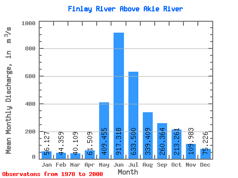
| Statistic | Jan | Feb | Mar | Apr | May | Jun | Jul | Aug | Sep | Oct | Nov | Dec | Annual |
|---|---|---|---|---|---|---|---|---|---|---|---|---|---|
| Mean | 56.13 | 44.36 | 40.11 | 61.51 | 409.45 | 917.32 | 633.50 | 339.41 | 260.36 | 213.26 | 109.98 | 75.23 | 263.38 |
| Standard Deviation | 8.36 | 5.82 | 6.44 | 17.91 | 169.93 | 184.32 | 144.68 | 89.91 | 71.75 | 68.63 | 21.75 | 15.71 | 25.91 |
| Min | 41.50 | 31.50 | 27.00 | 32.70 | 167.00 | 640.00 | 350.00 | 219.00 | 162.00 | 102.00 | 70.00 | 51.70 | 218.83 |
| Max | 72.20 | 54.90 | 58.50 | 115.00 | 686.00 | 1330.00 | 906.00 | 579.00 | 383.00 | 365.00 | 161.00 | 108.00 | 315.02 |
| Coefficient of Variation | 0.15 | 0.13 | 0.16 | 0.29 | 0.41 | 0.20 | 0.23 | 0.27 | 0.28 | 0.32 | 0.20 | 0.21 | 0.10 |
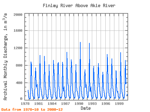
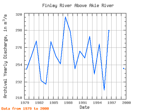
| Year | Jan | Feb | Mar | Apr | May | Jun | Jul | Aug | Sep | Oct | Nov | Dec | Annual | 1978 | 228.00 | 117.00 | 54.30 | 1979 | 42.70 | 31.50 | 27.00 | 32.70 | 248.00 | 876.00 | 805.00 | 310.00 | 231.00 | 200.00 | 101.00 | 69.60 | 247.88 | 1980 | 50.90 | 39.90 | 35.50 | 39.00 | 442.00 | 744.00 | 578.00 | 331.00 | 295.00 | 365.00 | 161.00 | 104.00 | 265.44 | 1981 | 71.70 | 51.60 | 46.20 | 51.80 | 643.00 | 1030.00 | 652.00 | 307.00 | 226.00 | 157.00 | 104.00 | 73.60 | 284.49 | 1982 | 53.60 | 40.80 | 38.40 | 43.80 | 179.00 | 1010.00 | 529.00 | 303.00 | 300.00 | 166.00 | 82.30 | 60.50 | 233.87 | 1983 | 49.50 | 41.90 | 32.20 | 60.80 | 304.00 | 814.00 | 510.00 | 350.00 | 266.00 | 164.00 | 99.30 | 60.00 | 229.31 | 1984 | 51.40 | 39.50 | 40.30 | 52.50 | 202.00 | 913.00 | 742.00 | 579.00 | 344.00 | 235.00 | 116.00 | 87.00 | 283.48 | 1985 | 56.40 | 40.30 | 35.30 | 39.20 | 370.00 | 828.00 | 862.00 | 318.00 | 298.00 | 206.00 | 74.00 | 54.50 | 265.14 | 1986 | 59.10 | 45.70 | 39.10 | 51.60 | 183.00 | 870.00 | 792.00 | 304.00 | 204.00 | 307.00 | 128.00 | 80.30 | 255.32 | 1987 | 61.70 | 51.40 | 44.90 | 59.90 | 390.00 | 1100.00 | 819.00 | 373.00 | 363.00 | 313.00 | 121.00 | 83.40 | 315.02 | 1988 | 58.60 | 46.30 | 42.30 | 67.50 | 579.00 | 929.00 | 741.00 | 506.00 | 230.00 | 177.00 | 113.00 | 64.40 | 296.18 | 1989 | 58.20 | 48.40 | 42.20 | 69.30 | 534.00 | 820.00 | 447.00 | 347.00 | 211.00 | 192.00 | 117.00 | 98.40 | 248.71 | 1990 | 59.80 | 40.90 | 44.40 | 65.80 | 549.00 | 1330.00 | 542.00 | 240.00 | 162.00 | 102.00 | 70.00 | 51.70 | 271.47 | 1991 | 41.50 | 45.50 | 34.10 | 60.60 | 509.00 | 697.00 | 519.00 | 290.00 | 372.00 | 323.00 | 152.00 | 108.00 | 262.64 | 1992 | 72.20 | 54.90 | 58.50 | 115.00 | 381.00 | 1310.00 | 563.00 | 219.00 | 192.00 | 307.00 | 121.00 | 89.90 | 290.29 | 1993 | 49.40 | 43.00 | 38.70 | 78.50 | 686.00 | 781.00 | 504.00 | 275.00 | 163.00 | 127.00 | 96.40 | 64.10 | 242.18 | 1994 | 51.10 | 37.60 | 38.10 | 69.40 | 514.00 | 840.00 | 645.00 | 367.00 | 383.00 | 226.00 | 113.00 | 79.20 | 280.28 | 1995 | 61.10 | 49.80 | 44.30 | 86.50 | 507.00 | 640.00 | 524.00 | 273.00 | 192.00 | 131.00 | 84.00 | 65.30 | 221.50 | 1996 | 48.60 | 37.60 | 32.90 | 73.70 | 249.00 | 1050.00 | 906.00 | 496.00 | 278.00 | 209.00 | 101.00 | 89.00 | 297.57 | 1997 | 70.50 | 52.90 | 45.80 | 65.90 | 470.00 | 948.00 | 618.00 | 372.00 | 292.00 | 218.00 | 121.00 | 79.90 | 279.50 | 1998 | 50.00 | 44.50 | 42.50 | 53.30 | 676.00 | 646.00 | 350.00 | 228.00 | 173.00 | 198.00 | 97.60 | 67.10 | 218.83 | 1999 | 59.10 | 49.00 | 42.40 | 51.00 | 226.00 | 1090.00 | 633.00 | 294.00 | 198.00 | 156.00 | 122.00 | 72.50 | 249.42 | 2000 | 57.70 | 42.90 | 37.30 | 65.40 | 167.00 | 915.00 | 656.00 | 385.00 | 355.00 | 198.00 | 118.00 | 73.50 | 255.90 |
|---|
 Return to R-Arctic Net Home Page